Askja
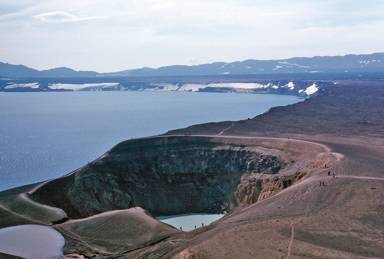
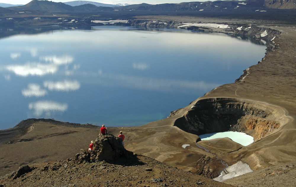
Caldera of the volcano Askja with Víti crater in the foreground and in the background Öskjuvatn
In Askja is a volcano in northeastern Iceland, he ruled as a central volcano, approximately 200 km long eponymous volcano system that Askja volcano system.
The volcano is now part of Vatnajökull National Park.
- 4.1 Prehistoric eruptions
- 4.2 outbreaks after the settlement and development of the youngest caldera 4.2.1 The Askja - fire
- 4.2.2 In the 1960s,
- 4.2.3 Recent Developments
- 6.1 The expeditions of gag and Grumbkow
- 6.2 Other German scientists
Name
The name of the volcano refers to the Icelandic word Askja, however, the " caldera " means in general language "box" in which geologists language.
In Norse mythology, Askja other hand, is equated with Asgard, the home of the Asengötter and high seat of Odin.
Central volcano Askja
Askja is a several hundred thousand -year-old central volcano in the highlands of Iceland north of Vatnajökull.
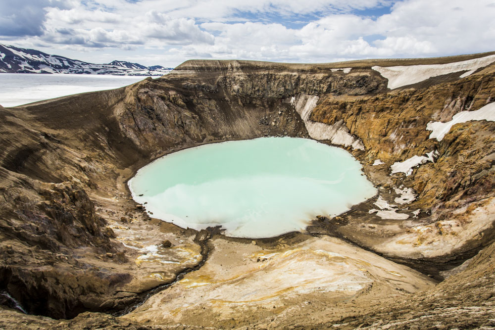
The mighty volcano is composed of at least three nested calderas (45 km ²), which together form the Dyngjufjöll massif. In the middle of the youngest, resulting in the vulkanotektonischen episode of 1875 Caldera is the lake Öskjuvatn, with 220 m of the deepest lake in Iceland. Even the smaller, also filled by a lake Víti crater is located in the caldera. The oldest documented Calder education took place at 8910 BC.
The volcano Askja rises to 800 meters above the surrounding plains and reaches the Þorvaldstindur, at the edge of the caldera in the Dyngjufjöll a height of 1510 m.
Askja volcano system
The central volcano dominates, approximately 200 km long, oriented from southwest to northeast column system. To him belongs, for example, the shield volcano Kollóttadyngja.
Expansion
The volcanic system extends from the central volcano Askja itself, which is located southwest around 40 km from the volcano Herðubreið panel and the oasis Herðubreiðarlindir, about 150 km north to the Melrakkaslétta Peninsula. At the same time, it is sufficient for about 30 km from the central volcano to the south.
With a total length of about 200 km, but a width of less than 20 km is according to T. Thordarson to the longest volcanic system in Iceland. However, other researchers have the total length limited to 120 or 170 km, depending on whether one wants to see a northern apparent demolition as its end or as a gap in it.
Various associated craters and volcanic mountains
The system of Askja include, for example, the panel volcano Herðubreið, the Palagonitrücken Herðubreiðartögl and the shield volcanoes Kollóttadyngja, Flatadyngja and Svartadyngja.
The crater of Sveinagrabens ( Isl Sveinagjá ) are located about 50 km north of the central volcano parallel to the volcanic system Fremrinámur.
Near the waterfall Dettifoss there are more craters.
Also part of the system is the ash crater Hrossaborg just south of the Hringvegur, about 20 km east of Námafjall. He was born in a large hydro- magmatic eruption about 7,000 years ago.
Eruption history
Prehistoric eruptions
It can be detected at the Askja volcanic activity dating back to several hundred thousand years.
Larger basalt eruptions in the Holocene were the Gígöldur and eruptions that created the lava fields Holuhraun ' and Þorvaldshraun.
Apart from the great calder forming eruption around 8500 BC in the southeast of the central volcano can be around 2050 BC show breakouts at Flatadyngja and in other areas in the northeast of the central volcano, for example, include the explosive as effusive phases, including also the formation of a lava lake counts, similar phenomena can provide around 1250 BC fixed, with this time the activity concentrated on the central volcano and Litladyngja. In both cases, both eruptions on a main crater as well as to more distant columns show.
Outbreaks after the settlement and development of the youngest caldera
Since its colonization by the end of the 19th century, two outbreaks in Askja system suspected ( 1300 and 1797), but both could not previously be detected accurately.
The Askja - fire
A long-lasting vulkanotektonische Episode sat at the Askja, however, one in 1874. She stopped intermittently until 1929, contained Riftepisoden, effusive and explosive eruptions at both the central volcano as well as to remote parts of the volcanic system and was called as Askja fire known.
The youngest caldera of Askja was established in March 1875 in a Plinian eruption as well as the smaller Víti crater.
Already in February 1874 saw steam clouds over the mountain range of the remote Dyngjufjöll. In December of the same year shook noticeably in the populated areas series of powerful earthquakes the area. In January 1875 it was recognized pillars of smoke and fire. Perhaps this stems mainly effusive phase the basaltic lava Holuhraun.
In February 1875, some people drove from the area of Myvatn to Askja. There they saw in the southeast of the caldera geysers of mud, but no real volcanic eruption. However, the soil was reduced by ten meters there.
Just three days later put a effusive eruption on a Sveinagraben. It is a 30 km long grave system 50 km north of the central volcano. During the several months long lasting outbreaks approximately 0.2-0.3 km ³ there were produced in lavas.
On March 29, 1875, the beginning of the explosive main phase is to be set. As a result, a Plinian eruption rained ash from 3:30 on East Iceland. As was the Danish geologist JOHNSTRUP to eruption site in the summer of 1876, he realized that a magma chamber after it had emptied itself, had collapsed in here. In this case, a smaller more caldera was formed with the dimensions 4580 x 2500 m and having its lowest point was 238 m below the bottom of Hauptcaldera in the existing. The volume of the slump crater is about two cubic kilometers, more than twice the erupted rocks, which suggests that there is also a considerable part of the magma as intrusions in the Calder walls or elsewhere in the volcanic system.
Shortly thereafter, the maar Víti formed in a hydro- magmatic eruption.
As a result, it turned out that it was the second or third most explosive volcanic eruption since the beginning of colonization in Iceland (after Hekla 1104 and Öræfajökull 1368 ). The ash fall was so violent, especially in the East Fjords, that pasture land was poisoned on long periods of time and many people emigrated, mainly from the already heavily colonized area of Jökuldalsheiði. The volcano had previously been virtually completely unknown.
At the same vulkanotektonischen Episode counting outbreaks in Askja volcano system between 1920 and 1930. Here there were five single eruption series of annular eruption columns to the caldera of Askja and a fissure eruption on a six-kilometer long fissure on the southern edge of the central volcano that produced the lava field Þorvaldshraun. These outbreaks were primarily effusive and played in two phases:. 1921-1923 and 1926-1930 The result was the lava fields Bátshraun ( Austurfjöll ) Mývetningarhraun, Kvíslahraun and Suðurbotnahraun. During the second eruption phase, inter alia, created a cinder cone in the lake and the lava field Öskjuvatn Þorvaldshraun.
In the 1960s,
The most recent series of eruptions occurred in the 1960s. Of 26 October 1961 and in November of the same year, new craters built up and created the lava field Vikrahraun The craters are located on a 0.6 km long from west to east oriented column on the east side of the Askja caldera. At the beginning of the effusive eruption could be seen 500 m high lava fountains. The product, a Aa lava field, covered six square kilometers. It was extended by pahoehoe lavas on eleven square kilometers.
Recent Developments
From 1988 to 2007, it was observed subsidence of the magma chamber.
Since 2007, however, it seems to fill up again. It is presumed magma accumulations in about three miles deep, which could indicate a renewed active phase. The earthquake activity has increased.
NASA Astronaut Training
As part of the Apollo program, NASA diverse geological excursions led in the 1960s (English Geologic field trips, short GFT ) by, two of which were contested in Iceland on the edge of Askja and near Krýsuvík on the Reykjanes Peninsula. The first excursion took place from 12 to 16 July in 1965 and concerned the first three astronauts groups, the second excursion on the astronauts groups four and five, including later the first man on the moon Neil Armstrong, was from 2 to 8 July completed in 1967. The aim of the excursions was to introduce the one hand, the astronauts in geological concepts and thus best possible preparation for the on the earth satellite likely to be encountered geology and on the other hand to train the crews of specific lunar missions targeted. It was also graduated from the so-called Moon Game, an exercise with the purpose to simulate the stay on the moon and to collect representative samples from the environment. In the appendix of the official NASA documentation it says to the excursions in Iceland:
"Probably the most moon -like areas of the field. "
" Probably the closest moon of the excursion places. "
Both excursions were led by the Icelandic geologist Sigurdur Thórarinsson and Guðmundar Signaldson.
German researchers at the Askja
The expeditions of gag and Grumbkow
In 1907, two German casualties during an expedition cruise on the Öskjuvatn. These were to the naturalist Walter von Knebel and the painter Max Rudloff. The fiancee gag, Ina von Grumbkow launched themselves in the next few years two expeditions to learn something about their fate, what you did not succeed. On the trips they took part themselves, a very unusual indeed for a woman of that time, and wrote a book about it. Ina von Grumbkow also had a monument in honor of the missing building, which is located on the west side of the lake.
In the companion and future husband of Ina Grumkow named Hans Reck, go basic research results for Askja back.
Other German scientists
Also, another German researchers focused in the 1930s on the research and mapping of the Sveinagrabens. However, they also dealt with the Askja central volcano and the Herðubreið.
Drekagil, Hvannalindir and Kverkfjöll
On the way to Askja one comes to the Drekagil, the Dragon Gorge, past.
25 km southwest of Askja is since 1973 the nature reserve oasis Hvannalindir. Here is said to have stayed late 18th century the lawless Fjalla - Eyvindur with his wife a few years.
About 40 km south of the Askja volcanic mountains Kverkfjöll lies with glaciers and active geothermal area.
Trivia
- The Boeing 757-200 Icelandair with the registration TF - FIR is named after the volcano.


