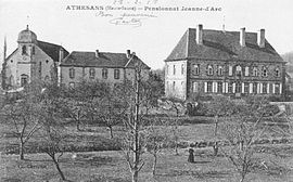
Athesans-Étroitefontaine
Athesans - ETROITEFONTAINE is a commune in Haute -Saône in the Franche -Comté.
Geography
Athesans - ETROITEFONTAINE lies at an altitude of 300 m above sea level, 8 km northeast of Villers Exel and about 26 km east of the town of Vesoul (air line). The double municipality extends on a plateau on the northeastern edge of the plain of Villersexel, west of Talniederung of Rognon, on the western edge of the heights of the Bois de Granges.
The area of 12.88 km ² municipal area includes a portion of the gently undulating landscape at Villers Exel. The central part of the area is occupied by the plateau of Athesans, the average is 300 m and its subsoil consists of sandy- marly layers of the Lias. It is passed with arable and meadow land, but also shows some of larger forest areas. The plateau is drained by the Rognon which accommodates various short side streams here. It flows through a wide Talniederung south to Scey. The municipal area also includes two ponds Etang de la Mouillère and Etang Lombard. To the west the area dates back to the little valley of the Ruisseau Basse -Fontaine, another tributary of the Scey.
East of Rognon Valley the land rises gradually. This is where the vast forest area of the Bois de Saint- Georges, which covers the western reaches of the hills and plateaus of the Bois de Granges. It is mainly composed of red sandstone. With 367 m de Saint -Georges is achieved the highest elevation of Athesans - ETROITEFONTAINE in the Bois.
The community consists of three parts:
- Athesans (300 m) on the plateau west of the Rognontals
- ETROITEFONTAINE (285 m) on the plateau north of the valley of Scey
- Saint- Georges ( 278 m), in the hamlet of Talniederung Rognon on the western edge of the Bois de Saint -Georges
Neighboring communities of Athesans - ETROITEFONTAINE are La Vergenne and Moffans -et- Vacheresse in the north, Mignavillers in the east, Senargent - Mignafans in the south and Villa fans and Gouhenans in the West.
History
Is first mentioned Athesans in 1174 under the name Athesun. Over time, the spellings Athesans ( 1431), Atessan ( 1696 ), Athesans -Saint- Georges ( 1789) and Athesans -les -Forges (1793 ) published. The municipal area was inhabited at the time of the Merovingians, as evidenced by the discovery of various tombs at Saint -Georges in the 19th century. Since the 12th century Athesans formed its own rule. Together with the Franche -Comté reached the village with the Peace of Nijmegen in 1678 definitively to France.
In 1717, the family Perreney de Baleure established the ironworks at Saint -Georges. She made a long time the economic basis for the population of the area and was nationalized after the French Revolution. The last blast furnace put into operation 1865. It was further reduced in the range of Athesans iron ore and salt, as well as in the Bois de Saint -Georges sandstone. Since the time of the French Revolution Athesans and Saint -Georges formed a community. The end of 1972 merged with Athesans ETROITEFONTAINE which had approximately 40 residents at the time, for double municipality Athesans - ETROITEFONTAINE. Since 2000 Athesans - ETROITEFONTAINE is a member of the 33- villages municipal association Communauté de communes du Pays de Villers Exel.
Attractions
The church of Saint -Servais in Athesans was built in the 19th century in the Gothic Revival style and has one of the oldest bells in the Haute -Saône ( 1500). The Château of Athesans dates from the 18th century, that of Saint- Georges, which belonged to the owner of the iron works, from the 19th century. In ETROITEFONTAINE there is a fountain from the 19th century.
Population
With 671 inhabitants ( 1 January 2011) Athesans - ETROITEFONTAINE one of the small towns in the Haute- Saône. Throughout the 20th century, the population of moving 420-610 people, with different variations were recorded.
Economy and infrastructure
Athesans - ETROITEFONTAINE was marked early on in addition to agriculture (crops, orchards and livestock ) and forestry also ironworks. Today there are various operations of local small businesses, especially in the fields of wood and food processing, and precision engineering. Meanwhile, the village has also changed into a residential community. Many workers are therefore commuters who engage in the larger towns in the vicinity of their work. Every year is carried out in Athesans the first Sunday in September, a fall market.
The village is situated away from the larger passage axes at the intersection of roads leading from Villersexel to Ronchamp or Lure to L' Isle- sur -le- Doubs. Further road links exist with Granges- la -Ville, Gouhenans and Beveuge.
Aillevans | Athesans - ETROITEFONTAINE | Autrey- le- Vay | Beveuge | Courchaton | Crevans -et -la- Chapelle- lès -Granges | Fallon | Faymont | Georfans | Gouhenans | Grammont | Granges- la -Ville | Granges- le -Bourg | Longevelle | Les Magny | Marast | Mélecey | Mignavillers | Moimay | Oppenans | Oricourt | Pont -sur- l'Ognon | Saint- Ferjeux | Saint- Sulpice | Secenans | Senargent - Mignafans | Vellechevreux -et- Courbenans | La Vergenne | Villa fans | Villargent | Villersexel | Villers- la -Ville
- Commune in the department of Haute- Saône
- Place in Franche -Comté


