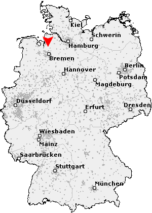
Axstedt
Axstedt is a municipality of the velvet municipality Hambergen and is located on the northern edge of the district Easter wood in Lower Saxony.
- 2.1 Amalgamations
- 2.2 traffic
- 2.3 Sons and daughters of the town
Geography
Geographical Location
The community Axstedt is located about 35 kilometers north of Bremen and about 30 kilometers south of Bremerhaven in the North German Plain. Dominated landscape of the place is its location in the Weser river mouths Geest, a glacial terminal moraine. Due to the small community of Meadow River Billerbeck, a tributary of the Lune flows.
Neighboring communities
Axstedt bordered to the south on the community Lübberstedt, in the east on the community Holste. North of the town Beverstedt located in Cuxhaven. To the west is the municipality of Hagen unit in Bremen ( also Cuxhaven ).
History
The megalithic stones at Axstedt lie northwest of the village. For the first time the church was mentioned in 1105 as Achenstedi documented.
Incorporations
Axstedt forms since the local government reform in 1974, with the municipalities Hambergen, Holste, Lübberstedt and Vollersode the Municipality Hambergen. The place was before the district Wesermünde.
Traffic
Excessive transport connection exists with the station Lübberstedt which is in the district of Axstedter Wohlthöfen, to the railway Bremen- Bremerhaven ( - Cuxhaven ). The highway 27 ( Walsrode Cuxhaven ) is 17 km away and can be reached via the highway 134. The main transport links to the county seat Osterholz- Beck and the regional center of Bremen is the 11 km national highway 74 Bremen -Stade.
Sons and daughters of the town
- Reinhard Woltman, hydraulic engineer


