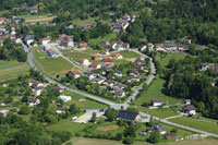
Béon, Ain
BÃ © is a municipality in the French department of Ain , in the Rhône -Alpes.
Geography
BÃ © located at 260 m above sea level, about twelve kilometers north- northeast of the town of Belley (air line). The village is located in the southeastern Bugey, on a debris cone at the southern foot of the Grand Colombier west of the Rhone Valley, at the edge of the vast marshland Marais de Lavours.
The area of 10.30 km ² municipal area includes a portion of the Rhone Valley. The southern part of the municipality is occupied by the still intact marsh area of the Marais de Lavours (230 m). In the extreme south of the municipality floor to the winding course of the Séran, a right side of the Rhone river reaches. To the north, the municipality's area extends over the steep and partially traversed by bands of rock slope down to the Jura ridge of the Grand Colombier. On its southernmost summit of the Pointe de Fautriolet, the highest elevation of BÃ © is achieved with 1443 m. The steep southern slope is divided by various gullies. At the foot of the slope talus were accumulated in each case.
The former seat of power Luyrieu is now a district of BÃ ©. The neighboring municipalities are Chavornay in the north, Culoz in the east, the south and Ceyzérieu Talissieu in the West.
History
The municipality of BÃ © was already inhabited during the Roman period. There wall foundations of the different Roman villas have been discovered. Since the 11th century formed Béon a rule among the lords of Lhuirieu / Luyrieu which were under the suzerainty of the Counts of Savoy. In the 13th century the village was elevated to a parish. The Treaty of Lyon Béon arrived in 1601 to France.
Attractions
The parish church of BÃ © dates from the 14th century and was extensively restored in 1968 for the last time. On a rocky ridge above the village are the ruins of the medieval castle Luyrieu raise. At the foot of this ridge stands the 19th-century Château de BÃ ©.
Population
With 401 inhabitants (as of 1 January 2011) BÃ © on one of the small communities of the department of Ain. After the population had decreased significantly in the first half of the 20th century, population growth was recorded since the early 1970s again.
Economy and infrastructure
BÃ © on until well into the 20th century, a predominantly coined by agriculture village. Today the vineyard on the slopes north of BÃ © plays a role as a source of income for locals. There are also some plants of the local small business sector. Meanwhile, the village has also changed into a residential community. Many working population commuters who engage in the larger towns in the vicinity of their work.
The village region has a quite well developed. It lies on the secondary road D904 which leads from Ambérieu -en- Bugey to Aix -les- Bains. Another road connection with Ceyzérieu. The regional station of Culoz is located two kilometers away.


