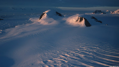
Bertrab Nunatak
- 77.866666666667 - 34.633333333333Koordinaten: 77 ° 52 '0 "S, 34 ° 38 ' 0 " W
Bertrabnunatakker ( former spelling Betrab - nunataks ) is the name given to three flat ridge of rock on the coast of Prince Regent Luitpold -Land in Antarctica, which protrude from the ice cap.
Discovery and geographical location
The nunataks were discovered in January 1912 by the second German Antarctic Expedition under Wilhelm Filchner, and named after Lieutenant General Karl Hermann Josef Wilhelm von Bertrab, the then head of the Department of the trigonometric Prussian land survey. There were in addition to the Moltke and Littlewood nunataks - the only ice-free regions, which were spotted by this expedition.
They are located at 250 meters above sea level, about 18 km inland of the Vahselbucht on the southeast coast of the Weddell Sea. Just north of Nunatakker opens the Lerch field glacier in the Vahselbucht.
Geology
The nunataks consist of horizontally mounted quartz porphyries, which were formed by volcanic activity before about 1110 mya. These are penetrated by several up to 5 m thick mafic and felsic transitions. Since its formation, these rocks have not been altered by mountain building processes, whereas the rocks in the nearest ice-free mountains ( Shackleton Range 300 km to the southeast, Heimefrontfjella 800 km in the northwest) have been before 550 mya folded during the formation of Gondwana and highly overprinted metamorphic. According to the current state of research, the Bertrab, Littlewood and Moltke nunataks are the only outcrops of an otherwise completely ice-covered micro- continent, which was incorporated in the formation of Gondwana in Antarctica.
Research stations
Argentina Opened in 1970, the summer station label on the southernmost nunatak. This station was expanded in 1979 and turned into a year-round occupied station and bares the name Belgrano II Station.


