Biebelried
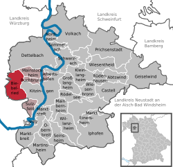
Biebelried is a municipality in the district of Kitzingen, Lower Franconia, and a member of the administrative community Kitzingen.
- 2.1 Amalgamations
- 2.2 Population development
- 3.1 Coat of Arms
- 5.1 monuments
- 6.1 Economy, agriculture and forestry
- 6.2 traffic
- 6.3 Education
Geography
Geographical Location
Biebelried lies in the region Kitzingen.
Community structure
The municipality Biebelried has three officially named districts:
- Biebelried
- Kaltensondheim
- Western Home
There are the districts Biebelried, Kaltensondheim and West home.
Neighboring communities
Neighboring municipalities are (from north clockwise beginning ): Dettelbach, Mainstockheim, Buchbrunn, Kitzingen, Ochsenfurt, Randersacker, Theilheim and rotting village.
History
Biebelried was first mentioned in the 9th century. After the Lords of Biebelried 1244 the village passed into the possession of the Knights of Malta or later. The latter was abolished in 1806 and the site coincided with the accession to the Confederation of the Rhine to the Grand Duchy of Würzburg, with whom he came to the Kingdom of Bavaria in 1814. In the course of administrative reform in Bavaria, was born with the congregation of 1818, the current community. Biebelried heard in the municipal reform 1978 management community Kitzingen.
Incorporations
On 1 May 1978, the formerly independent communities Kaltensondheim and westheim were incorporated.
Population Development
Policy
Mayor Renate Zirndt ( General Civil List ).
Coat of arms
Blazon Over blue Bogenschildfuß with four silver poles in red between two growing silver ears notched a floating silver cross of St. John
Coat of Arms history In 1978, originated from the formerly independent communities Biebelried, Kaltensondheim and West home, the current community Biebelried. The coat of arms contains references to these three former municipalities. The cross of St. John reminds us of the same order, which was well off in all three places and in Biebelried einrichtete one coming. He practiced from 1244 to 1806 in Biebelried mainly the local rule from. The sign foot comes from the coat of arms of the lords of Seinsheim -Schwarzenberg, who had the dominion in cold Sontheim. The silver spikes were the submerged crest of westheim removed and have the same attention to the agricultural orientation of the community. The coat of arms was granted by the government of Lower Franconia on September 26, 1991
Religion
Biebelried is predominantly Catholic, Protestant West Home and Kaltensondheim each half Catholic and Protestant.
Culture and sights
Highlight of the year is the St John festival which takes place at the St. John's Place.
Monuments
Economy and infrastructure
Economy, agriculture and forestry
It was in 1998 according to official statistics in the manufacturing sector and 105 in the area of trade and transport 9 to social insurance contributions at work. Social insurance contributions at residence, there were a total of 372 in the manufacturing sector, there were none, the construction sector 4 farms. In addition, in 1999, there were 67 farms with an agricultural area of 2689 hectares, of which 2595 were arable land and 81 permanent grassland.
Traffic
Biebelried located at the junction of the A 3 (Frankfurt- Nuremberg) with the A 7 (Kassel -Ulm ): Motorway Biebelried.
Education
There is a kindergarten with 40 children (as of 1999).


