Catalog Service for the Web
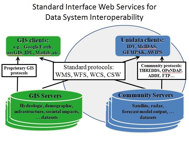
Under a Web Catalogue Service ( WCAS ), also called Catalogue Service for the Web (CSW ), refers to the Internet-based publication of information on spatial applications, Geoservices and spatial data (metadata) in a spatial data infrastructure. It is important that this service itself does not contain spatial data, but merely descriptive metadata Selbiger. This geo-service has been specified by the Open Geospatial Consortium ( OGC) and released under the version 2.0.0. The corresponding application profile is available for download free of charge. The managed metadata are 19115 ( for spatial applications and spatial data ) and ISO 19119 ( for Geoservices ) encoded according to ISO standards. The CSW has the processing modes selection ( Discovery ), continuation ( Transaction) and harvesting ( harvesting). Special importance attained the Catalogue Service by the EC Directive INSPIRE.
Selection
This mode is supported by the operations GetCapabilities, DescribeRecord, GetRecords and GetRecordById. The selection is from the metadata information systems ( GeoMIS ) performed the spatial data infrastructures, in order to give customers information about a spatial applications, Geoservices or spatial data. A GeoMIS is often an application within a geoportal.
The selection being in accordance with the CSW - standard 2.0.2 a function that must be implemented in order to comply with the standard.
Continuation
This mode is supported by the operation Transaction. This makes it possible to insert metadata documents in the catalog (insert), update ( update ) or remove (Delete). The continuation via - Internet -based - metadata editors. The operation is but probably not provided by free catalog providers available on the internet.
The continuation is an optional feature for the CSW standard 2.0.2. They need not, but may be implemented.
Harvest
This mode is supported by the operation harvest resource. With this operation, you transfer the metadata from an external catalog service ( CSW) in the treasury. This is done cyclically through a common point ( business and / or coordinating body ) in a spatial data infrastructure. The federal states in Germany reap from the local, regional or national catalogs and offer their customers a centralized search facility. The national catalog in GeoPortal.Bund is not based on the harvest mode. He even uses the selection mode for all the statewide professional neutral and nationwide subject-specific catalog for his research. The harvesting of metadata has the disadvantage that multiple entries can be caused by recursions of concatenated catalog services.
The harvest is an optional feature for the CSW standard 2.0.2. They need not, but may be implemented.


/ITSM%252520Framework.png)

