Dujiangyan irrigation system
The Dujiangyan irrigation system is located near the city of Dujiangyan, located 60 km north- west of the city of Chengdu in the place where the Min River (岷江; Pinyin: Min Jiang ) flows from the hills to the plains of Chengdu. There is a weir system, which has been monitored for 2,300 years, the Min River and large amounts of water for irrigation branches of the Red Basin. The facilities were built from 256 BC to 251 BC under the Qin administrator lǐ Bing (李冰) and his son. In 2006 they were supplemented by the new Zipingpu Dam.
Since 2000, Dujiangyan is taken together with the Qingcheng Shan in the UNESCO list of world cultural heritage. Since 1982 it is on the list of monuments of the People's Republic of China. Other is a listed ancient water construction projects in China include the Zheng Guo Canal and the Ling Canal.
Construction
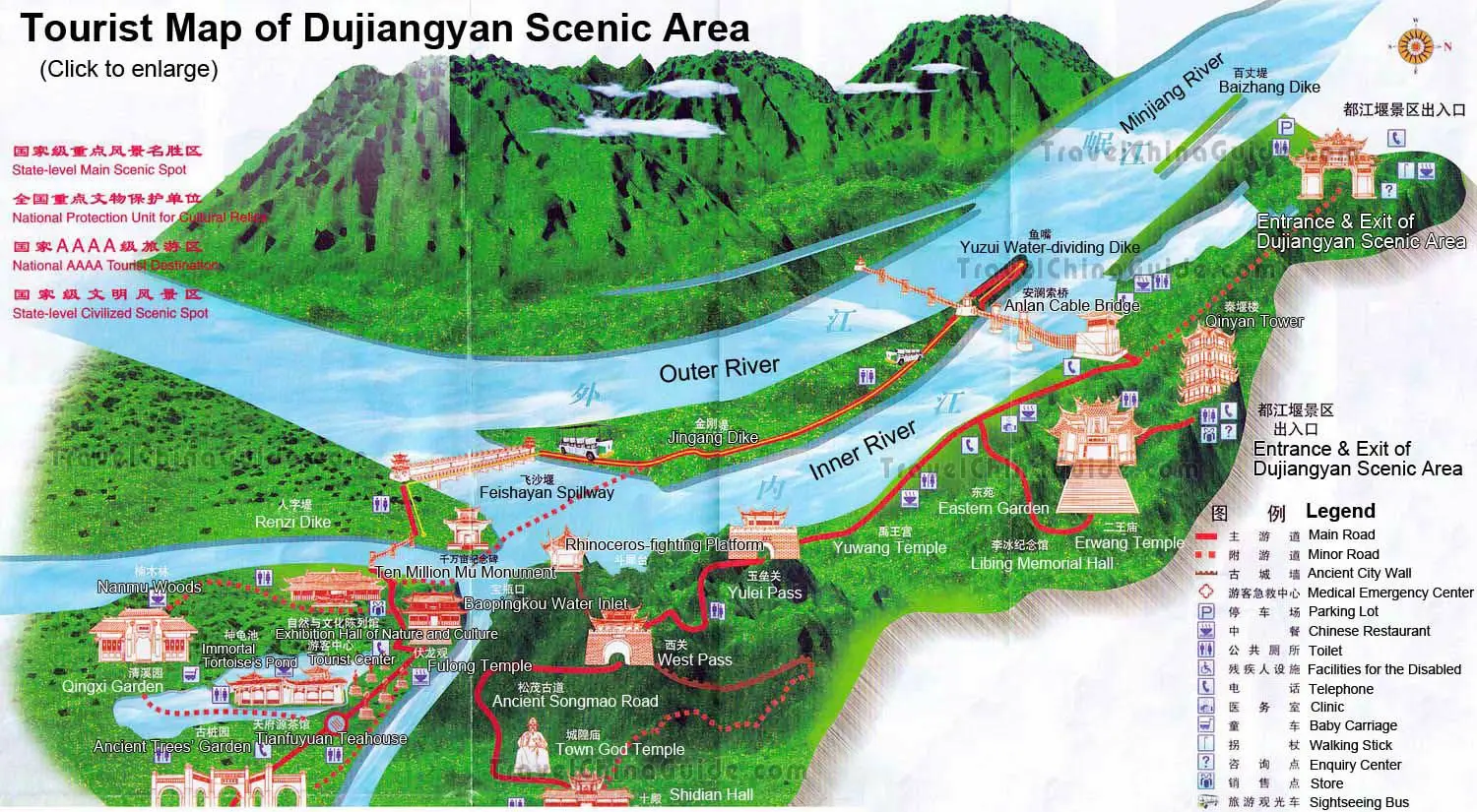
The system consists of the following areas: the fish's mouth (鱼嘴; yuzui ), the quicksands weir (飞沙 堰; Feishayan ) and the precious bottle neck (宝 瓶口; băopíngkŏu ).
The fish's mouth is a shallow dike that divides the Min lengthwise into an inner and outer power. A higher dike built - is on the fish's mouth - something reset. The outer westernmost stream continues to flow as min, while the inner, easternmost, is the source for the water to be derived. The shape of the fish's mouth causes a seasonal distribution of the different water masses. In the low-water spring 40 % of the water flow in the outer stream and 60% in the inner; flood season, the water level rises, so he flooded the fish's mouth and reversed the splitting ratios: now 60 % of the water flow in the outer flow. By the construction, the depth of water is passed to the main portion of sand and particulates in the outer flow, while the clearer surface water flows into the inner channel.
To control the amount of water in the inner current exists an overflow. This is the shifting sand weir, a 710 m downstream and 240 m wide opening in the dike. At high tide, the excess flows out through the weir in the outer flow, and on top of sand and stones are flushed, preventing siltation of the inner stream.
Through the precious bottle neck, the water is eventually diverted to the fields in the plane of Chengdu. The precious bottle neck is an artificial cut in the edge of the mountain Yulei Shan (玉垒山), 120 m from the outlet of the shifting sand weir. It is up to 28.9 m wide, 18.8 m high and has a length of 36 m. Following the natural gradient flows in channels to the southeast and watered the plain of Chengdu.


