Khian Sa District
Amphoe Khian Sa ( Thai: อำเภอ เคียน ซา ) is a district ( Amphoe - administrative district ) in the province of Surat Thani. The Surat Thani Province is located in the southern region of Thailand.
Geography
Amphoe Khian Sa is located about 60 kilometers from the provincial capital of Surat Thani. It is located in Khian Sa basin which is drained by the Maenam Tapi. The river also forms the eastern boundary of the district.
The neighboring Amphoe are (from north clockwise): Khiri Council Nikhom, Phunphin, Ban Na Doem, Ban Na San, Wiang Sa, Phrasaeng and Phanom.
Mainly operating in Khian Sa rice cultivation, plantations of latex trees are also common. Along the river it is quite marshy, best seen in Nong Thung Thong swamp.
The Highway 44 Krabi by Amphoe Khanom Nakhon Si Thammarat province in common is the main artery of the district.
History
Khian Sa was founded initially as a sub-district ( King Amphoe ) on 15 December 1970 by the two tambon Khian Sa and Phuang Phromkhon was separated from Amphoe Ban Na San. He received full Amphoe status on 20 May 1974.
Management
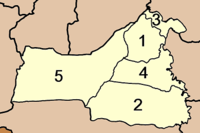
The Amphoe Khian Sa is divided into five subdistricts ( tambon), which in turn have together 52 municipalities ( Muban ). The Tambon Khian Sa has a city - state ( thesaban tambon), each of the Tambon is managed by a Tambon Administrative Organization ( TAO). Tha Chana itself has a city - state ( thesaban tambon).


