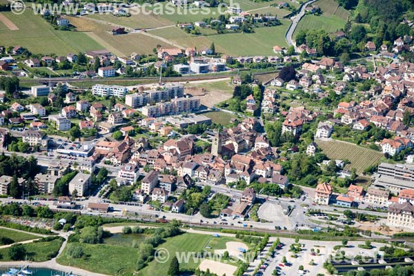
Saint-Blaise, Switzerland
Saint -Blaise is a municipality in the district of Neuchâtel canton of Neuchâtel in Switzerland. The former German name St Blaise is no longer used today.
Geography
Saint -Blaise is located at 440 m above sea level. Level, 5 km northeast of the capital of the canton of Neuchâtel (air line). The village is located at the foot of the Jura, on the north shore of Lake Neuchâtel, both sides of the village Bach Le Ruau.
The area of 8.9 km ² large municipality area includes a portion of the riparian strip on Lake Neuchâtel in the mouth of the Ruau. To the east the area extends over the valley with the lake Loclat up to the height of the Plateau de Wavre (470 m above sea level. M. ). In the north, the community area of the Roches de Châtollion ( 671 m above sea level. M. ) and the little valley of the Ruau extends to the anticline of Chaumont, the southeast slope (La Grande Côte ) is densely forested. At the height of 1,140 m above sea Chaumont is with. M. the highest point of Saint -Blaise reached. From the municipality surface 1997 18 percent went to settlements, 54 percent of the forest and shrubs, 27 percent to agriculture and slightly less than one percent was unproductive land.
At Saint -Blaise include the hamlet Voëns ( 584 m above sea level. M. ) and Le Maley (617 m above sea level. M. ), both in a trough on the southern slopes of Chaumont, as well as some individual farms. Neighboring municipalities of Saint -Blaise are Hauterive, Neuchâtel, Cressier, and La Tène Cornaux.
Population
With 3258 inhabitants ( 31 December 2012) Saint -Blaise is one of the larger municipalities in the canton of Neuchatel. Of the 82.6 % inhabitants are French-speaking, German-speaking 7.8 % and 3.5 % Italian-speaking (as of 2000). The population has increased significantly, particularly since 1950.
Economy
Saint -Blaise was once mainly a wine village, but developed in the late 19th century to the industrial community and throughout the 20th century to the residential community. Today Saint -Blaise has grown together with the neighboring communities Hauterive and Epagnier. At the optimally exposed to the sun slopes above the north shore of Lake Neuchâtel is viticulture (see also the article viticulture in Switzerland) operated, but the opposite has previously not so very important. On the eastern edge of the village of a larger industrial and commercial area, in which, among other things, an industrial bakery, a watch factory and enterprises of mechanical engineering are developed.
From 1903 to 1934, the company Martini was established in Saint -Blaise, the most significant and most successful Swiss production site of cars.
Traffic
The community is conveniently moderately well developed, it is on the main road 5 of Biel / Bienne to Neuchâtel. In December 1995 the center after the opening of the A5 motorway was relieved of through traffic. The highway runs along the shore area in deep level, mostly in Tagbautunnels. After the construction of the lakeshore has been redesigned and furnished a recovery zone.
On 7 November 1859, the railway line from Neuchatel to Le Landeron opened with a station in Saint -Blaise, whose western part is located in the municipality of Hauterive. The inauguration of the line Neuchatel -Bern on July 1, 1901. Saint -Blaise is also serviced by the network of transport en commun de Neuchâtel et environs, including the line 1 of Neuchâtel trolleybus. A coach line travels via Narrow by Lignières. Furthermore, Saint -Blaise is connected during the summer months over the maritime transport system on Lake Neuchâtel with the other Seeanstössergemeinden and with Lake Murten and Lake Biel.
History
The place can look back on a very long urban tradition. Already around 3000 years BC the area was inhabited. It remains of a Neolithic village from the Bronze Age settlement traces of Helvetic farmers, and traces have been found dating back to Roman and Migration period, indicating a potentially continuous settlement since 5000 years.
The first written mention of the village was carried out in 1011 under the name Arins. 1209 appeared the name Sanctus Blasus, which was initially given only for the lower part of the village, while the upper part was called Arens continues. Saint -Blaise belonged from the 13th century to the County of Neuchâtel and was part of the castle Bailiwick Thielle. Since 1648 Neuchâtel principality and 1707 was linked by personal union with the Kingdom of Prussia. 1806, the region was ceded to Napoleon I. and came in 1815 during the Congress of Vienna to the Swiss Confederation, the kings of Prussia until 1857 Neuchâtel trade also prince of Neuchâtel remained. 1888 were the hamlets of Le Voëns and Maley, the previously formed their own village, connected with Saint -Blaise.
Attractions
Today's Reformed Church (Temple) Saint -Blaise was built in the 15th and 16th century in the Gothic style with distinctive front tower and arched portal. It stands on the site of a Carolingian chapel and is the only historic building of Saint -Blaise, which is classified as a historical monument of national importance.
In the center are numerous patrician houses from the 16th to the 18th centuries, including the Maison de la Dîme of 1581 hexagonal stair turret and the Maison Neuve 1660, also with a stair tower. The Hôtel communal comes from 1694th The mill ( moulin du Haut ) was rebuilt at the beginning of the 16th century by Jean Dardel again. Since 1979, the mill wheel is back in service (but not the mill).
Situated on the shores of Lake Neuchâtel is the Laténium, an important archaeological museum on culture and history of the Celts, especially the La Tène period.
Community partnership
Saint -Blaise in 1961 a partnership with the German city of St. Blaise in the Black Forest (Baden- Württemberg) is closed.


