1983 Atlantic hurricane season
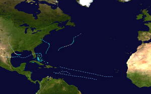
The 1983 Atlantic hurricane season officially began on June 1, 1983 and lasted until 30 November. This data typically limit the period of the year in the form most tropical cyclones in the Atlantic Ocean. It was the least active hurricane season in the Atlantic Basin since 1950.
Overall, only seven tropical depressions, four of which reached at least the strength of a tropical storm formed. The Accumulated Cyclone Energy is the lowest since 1950.
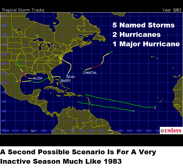
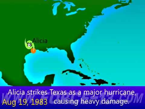
The season started later than usual, the first tropical depression formed until 29 July; the second followed two days later. None of them could intensify. Hurricane Alicia was formed on August 15 as the third low-pressure system of the season, intensified the next day to the hurricane and arrived on 18 August on the coast of Texas, where the storm wreaked damage to property in the amount of 2.6 billion U.S. dollars. Hurricane Barry was born on August 25, crossed Florida and strengthened. In a hurricane Barry broke up on 30 August after the landfall at Brownsville.
Hurricane Chantal, the third and final hurricane of the year, formed on 10 September, but remained far at sea, where he was absorbed on 15 September by a frontal system. The Tropical Depression Six formed on September 19 and caused heavy rainfall on the Caribbean islands before it degenerated into a tropical wave on September 21. Dean was formed on 26 September as a tropical storm and moved northward. He retired on 29 September on the Delmarva Peninsula and its resolution on the coast of Virginia drew the line under the less active season.
Saisonvorprognosen and actual activity
A prediction of hurricane activity was created in the time by hurricane experts such as William M. Gray and his team at Colorado State University. A normal season, as defined by NOAA, has six to fourteen named storms, of which four to eight will be a hurricane, one to three hurricanes to so-called major hurricanes, ie they reach at least Category 3 on the Saffir -Simpson Hurricane Scale. Published on July 23, 1983 prediction went after the slow start of the season on the assumption that a total of eight storms would form, of which five hurricane status should achieve. The prediction did not indicate how many of the hurricane to reach Category 3 or higher. This prediction proved to be too high, since were only four named storms by the end of the season, including three hurricanes.
The season was due to strong wind shear in height very little active. Unusually strong was the wind shear, especially in the Caribbean and on the open Atlantic, so that in areas of disturbed weather the formation of convection was prevented, so that there are no areas of low pressure could develop. About sixty systems had formed on the coast of Africa and moved westward across the Atlantic, but once they reached the Leeward Islands, they broke easily. The only area in which the wind shear was low - formed from the Gulf of Mexico and the Atlantic Ocean north of the Bahamas and east of Florida - was the formation region of the four named storms of the season. The Atlantic hurricane season in 1983 was the least active season in the Atlantic hurricane season 1930, in which emerged only two storms. 1982 and 1983 are the only case of two consecutive years since systematic observations hurricane in 1871, in which originated in the Caribbean Sea no hurricanes. 1983 was also the first time since 1871 that no storm south of 25 ° north latitude formed.
1983 was the first season, announced for the National Hurricane Center numeric landfall probabilities. Such probabilities have been calculated earlier to be used in individual storm warnings, but these figures were not previously published. The probabilities that were called during the existence of Alicia were correctly pointing out that Galveston and the surrounding area would be hit most by the storm.
Storms
Tropical Depression One
The Tropical Depression One formed on 29 July from a tropical disturbance near the Leeward Islands. The National Hurricane Center indicated the possibility of stepping into a tropical storm, but wind shear in the height prevented any development. The next day, the system broke up.
Tropical Depression Two
An area of disturbed weather in the mid-Atlantic managed to train enough organization to be classified on July 31, as Tropical Depression Two. The low moved across the Atlantic without reinforcing, as it was exposed at the level of strong wind shear and dissipated near the Lesser Antilles on August 3 on.
Hurricane Alicia
The system, which evolved into the Hurricane Alicia, had its origin at the western end of a frontal trough that extended from New England to the Gulf of Mexico. On satellite images, a child depression was evident, which in the vicinity of the trough moving off the coast of Alabama and Mississippi, and was possibly a precursor system Alicia. The air pressure in the Gulf of Mexico was high and remained so in the early stages of hurricane development. On August 15, a ship measured a barometric pressure of 1015 mbar ( hPa), has just been classified as the system to Tropical Storm Alicia. With high pressure in the area Alicia remained a small system.
The control currents above Alicia remained consistently low during the lifetime of the storm, but a back formed well north of the developing storm. With variations of its air pressure of the storm began on August 16 with a west facing drift. This did not last long, because Alicia turned to northwesterly course towards Texas. In the period between the 16th and 18th August an anticyclone had formed and, together with the slow forward movement over warm waters, this led to a rapid intensification over Alicia. The air pressure in the center Alicia went in the 40 hours before landfall to a millibar per hour back. Alicia reached on 18 August with a sustained wind speed of 185 km / h and 962 mbar ( hPa) the greatest strength and arrived the same day at Galveston as a Category 3 hurricane over land. There, Alicia weakened rapidly and accelerated across the Midwest to the front before they broke up over Nebraska on August 21.
As Alicia wandered northward, led the humidity of the residual lows in several states to heavy rains. Houston showed severe damage, including thousands of windows on the skyscrapers in the city center. All in all, twenty-two people killed Alicia and resulted in a damage of 2.6 billion U.S. dollars ( 1983).
Hurricane Barry
Hurricane Barry has its origin in a tropical disturbance that broke up on 13 August from the northwest coast of Africa. During most of the hurricane season the northwestern tropical Atlantic wind shear was influenced in height, making the development of tropical systems has been hampered. Because of these conditions, the disturbance to the approach to the Bahamas on August 22 could not amplify. A weak trough pushed the disorder in an area with few shears, and the disturbance could develop on the evening of 23 August as Tropical Depression Four. The low was just northeast of the northern islands of the Bahamas, as it is on the morning of 24th August's a tropical storm intensified.
As Tropical Storm Barry turns to the west and as the wind shear increased again, Barry weakened against the low pressure area. The depression arrived at Melbourne on the morning of the 25th of the month of August on the mainland. After the system moved into the eastern Gulf of Mexico, it was still under the influence of pressure from high altitude winds. It was only in the central region of the Gulf Barry reached gale force again. Barry rapidly intensified and became a hurricane on 28 August. Before landfall in the afternoon of that day at the Brownsville Barry reached its peak with continuous wind speeds of 130 km / h and a minimum central pressure of 986 mbar ( hPa). The remnants of the hurricane, which declined rapidly over the country, dissolved on 29 August over the mountains of northern Mexico.
Hurricane Chantal
The weather disturbance that would be to Chantal soon arose on the morning of 10 September in a vast area of low pressure. The error that was embedded off the coast of Bermuda in the Deep, was a residual of an old frontal trough that had extending from Hispaniola to the central north Atlantic. The weather disturbance was the north-eastern part of a low pressure system. On 10 September, a reconnaissance aircraft sustained winds of 50 km / h and a minimum air pressure of 1010 mbar ( hPa) firmly. Based on these measurements, the low- pressure system has been classified as the fifth tropical depression of the 1983 season.
The depression hiking up to 160 km closer to Bermuda and intensified slowly but surely. In the late afternoon the storm winds had reached 60 km / h and was named Chantal. Chantal rapidly intensified and reached on the morning of September 11, 105 km / h Chantal turned to the east and managed to form a weak discharge with cirrus clouds. On the morning of 22 September, Chantal has been classified a hurricane, the follow-up analysis showed, however, that the storm of this strength could have already reached the night before. During the next few hours, the hurricane changed little, the following night however, the system lost its organization and was downgraded to a tropical storm.
Overnight, the convection of Chantal dissolved completely and the northbound forward speed decreased. A weak wave Chantal urged forward and then the system went into a front system the evening of 14 September on. The impact on Bermuda were minimal; the wind reached 25 km / h and a few thunderstorms went down. Chantal led on the east coast of the United States to a swell 9 to 12 m.
Tropical Depression Six
The Tropical Depression Six formed on 19 September. It caused heavy rainfall in the Leeward Islands, before it weakened on September 21 near the Dominican Republic in a tropical wave.
Tropical Storm Dean
Tropical Storm Dean had its origin within a frontal cloud band that moved off the east coast of the United States on September 22. During the next few days the cloud band from the Bahamas to Bermuda behind was nearly stationary. During this time, a high-pressure cell was set at 1035 mbar (hPa ) over the northeastern United States. This led to a strong pressure gradients and winds which almost reached gale force along the Atlantic coast.
A near-surface circulation formed on September 26 from the frontal cloud band, about 740 km east of Central Florida. Dean was first recognized on the afternoon of September 26 as a subtropical storm. A reconnaissance aircraft of the United States Air Force was sent on September 27 to Dean. It was about 37 km from the storm center wind speeds of just 55 km / h fixed. An air pressure of 999 mbar ( hPa) pointed out that Dean stepped on his train to the north. The satellite images showed that the subtropical storm broke out of the cloud mass. The data also showed that the storm took on tropical characteristics and on the afternoon of September 27, the NHC classified the storm as a tropical storm.
Dean's winds peaked on 28 September at 80 km / h as the storm moved northward yet. Deans circulation turned on September 29 to the northwest and was with his landfall on the Delmarva Peninsula, one of three storms recorded in history who did this, previously these were the tropical storms Bret in 1981, Danielle 1992. Dean broke up on 30 September over land.
Storm warnings were issued for Dean on the coast between North Carolina and Rhode Iceland. Dean led from the border with North Carolina / Virginia up to New England to heavy rain. Virginia reported rain 25-76 mm. The highest rainfall was measured with 117 mm at the Cockaponset Ranger Station in Connecticut. Damage caused by the tropical storm were limited to coastal erosion and flooding in the states at the central portion of the U.S. Atlantic coast.
Season overview
Accumulated Cyclone Energy (ACE )
The adjacent table shows the ACE for each storm this year. The ACE describes the energy of a tropical storm by the strength of a storm is multiplied by the duration, that is, long -lasting storms and severe storms have a high ACE value. Traditionally, from the NOAA only storms with wind speeds of over 34 knots (63 km / h) recorded.
The 1983 season had an ACE of 16.9 ( 16.86 ), which is well below average and the lowest level since the Atlantic hurricane season in 1914 showing that an ACE of 2.53 had.
Storm names
The following names were used for naming storms. With the exception of Alicia these names were reused in the Atlantic hurricane season in 1989. This list of names came first time in 1983 for use as the National Hurricane Center had set up new lists of names after the 1978 season.
- Alicia
- Barry
- Chantal
- Dean
- Erin
- Felix
- Gabrielle
- Hugo
- Iris
- Jerry
- Karen
- Luis
- Marilyn
- Noel
- Opal
- Pablo
- Roxanne
- Sebastien
- Tanya
- Van
- Wendy
The World Meteorological Organization has the name Alicia painted in the spring of 1984 by this list. That's why Alicia was in 1989 replaced by Allison.


