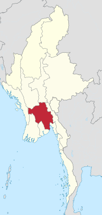
Bago Region
18.46666666666796.15Koordinaten: 18 ° N, 96 ° E
The Bago Division ( also Pegu, Paigu ) is one of the 14 administrative units of the State of Myanmar.
Of all the Divisions and States, the Bago Division has the most borders in the inland: in the northwest it borders on the Magwe, to the north of Mandalay, on the south by the Yangon and on the southwest by the Irrawaddy Division. In the East, their longest border is the Kayin State in the southeast shares the Bago - Division a small border strip with the Mon State and eventually contacts in the West or the Arakan ( Rakhine ) State.
The Bago Division occupies an area of 39,404 km ². After the Sagaing Division is the second largest division of Burma, and among all States and Divisions, it ranks fourth.
Beginning of 2005 the population was 5.555 million according to official figures. The largest city is the capital of the same Bago.
The division consisted of five districts in 1891: the city of Rangoon, Hanthawadi ( formerly Rangoon ), called Bago, Tharawadi and Prome. The area was 24,084 km ². The country is covered almost half of the delta of the Irrawaddy.
The inhabitants are predominantly Mon ( called by the Burmese Talaing ).
Divisions: Bago | Ayeyarwady | Magwe | Mandalay | Sagaing | Tanintharyi ( Tenasserim ) | Yangon
States: Chin | Kachin | Kayah | Kayin | Mon | Rakhine ( Arakan ) | Shan
- Division (Myanmar )
- Bago Division


