Belsh
40.98111111111119.890277777778156Koordinaten: 40 ° 59 'N, 19 ° 53 ' E
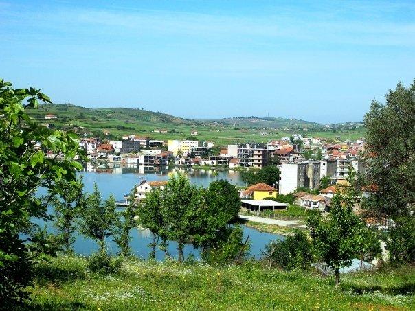
Belsh ( Albanian: Belshi, rarely Belesh respectively. Beleshi ) is a small town in central Albania with 8781 inhabitants ( 2011 census ), with the local authorities specify some 14,000 inhabitants ( 2008). It is the third largest city in the district of Elbasan. Belsh is located approximately 25 kilometers southwest of the city of Elbasan and about the same distance east of Lushnja in Dumreja called hills.
The Dumreja - in geology is called the Karst Plateau as evaporiter Diapirdom of Dumrea - lies between the rivers Shkumbin in the north, the Devoll in the east, the Seman in the south and the Myzeqe level in the West. Characterised is the area of up to 300 meters, in the far north, even up to 450 feet high rising hill, Polya and karst hollow forms. In these up to 15 meters deep valleys around 80 small karst lake formed ( Liqenet te Belshit / Dumrea Lakes ). One of them is the Liqeni i Belshit, along its western and northern shoreline stretches the city.
The region of Belsh was inhabited in ancient times. On the opposite shore at a place Gradishta Illyrian fortification and settlement were found on a hill remains. Later, a Greek colony prospered, the place in Roman times as a trading not too far away from the Via Egnatia. A little further south near the town of Serafani was a temple that was dedicated to Aphrodite. In the adjacent lake many terracotta goods were found, which were sunk there in honor of the goddess. The findings of a princely tomb are exhibited in Tirana. In the 6th century the fortified ancient city was destroyed by invading Slavs.
In Belsh there is a middle school and a hospital. The community Belsh includes in addition to the center ( Qender ) the following twelve villages: CEPA, Dushk, Belsh - Fshat, Shkoza, Qafë Shkalla, Seferan, Troy, Shkendi, Gradischte, Marinez, Stith and Stanaj.
The surroundings of Belsh is used by agriculture. It is assumed in the Dumrea also gas deposits.


.jpg)