Cha-uat District
Amphoe Cha- uat ( Thai: อำเภอ ชะอวด ) is a district ( Amphoe - administrative district ) in the southern province of Nakhon Si Thammarat. The Nakhon Si Thammarat province is located in the southern region of Thailand.
Geography
The Nakhon Si Thammarat province lies about 780 kilometers south of Bangkok on the east coast of the Malay Peninsula to the Gulf of Thailand.
Neighbouring districts (from west clockwise): Amphoe Thung Song, the, Chulabhorn, Ron Phibun, Phra Kiat Chaloem, Chian Yai and Hua Sai in the province of Nakhon Si Thammarat Province, Amphoe Ranot Province Songkhla, Amphoe Khuan the Khanun and Pa Phayom the Amphoe Huai Yot Phatthalung Province as well as in the province of Trang.
The National Park Khao Pu - Khao Ya is located in Nakhon Si Thammarat - Mountains at the Granze the provinces of Phatthalung and Trang.
History
Cha- uat was established initially in 1923 as a sub-district ( King Amphoe ), by being separated from Amphoe Ron Phibun. On January 1, 1953 Cha- uat has been promoted to Amphoe.
Management
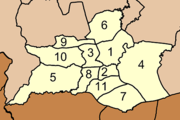
Amphoe Cha- uat is in eleven communities ( tambon) divided, in turn, in 88 villages ( Muban ) are divided.
Cha- uat ( Thai: เทศบาล ตำบล ชะอวด ) is also the name of a small town ( thesaban tambon) in the district, it consists of parts of the Tambon Cha- uat.
In addition, there are eleven " Tambon Administrative Organizations" (TAO, องค์การ บริหาร ส่วน ตำบล - administrative organizations) in the district.


