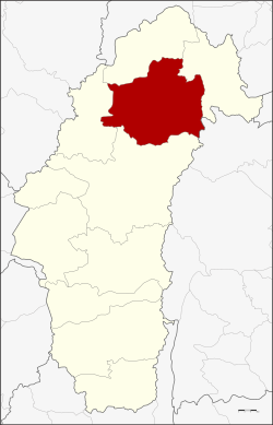
Lom Sak District
Amphoe Lom Sak ( Thai อำเภอ หล่มสัก, also Lomsak ) is a district ( Amphoe - administrative district ) in the province of Phetchabun. The Phetchabun province is located in the extreme southeast of North Thailand. The capital of the district is also called Lom Sak.
Geography
Neighboring districts are ( from north clockwise ): Amphoe Lom Kao and the Nam Nao of Phetchabun Province, Amphoe Khon San ( Chaiyaphum province ) and the Amphoe Mueang Phetchabun and Khao Kho ( Phetchabun province ).
Lom Sak is the starting point for a tour of the National Park Phu Hin Rong Kla ( Phitsanulok province ), which is famous for its scenic wilderness and unique for Thailand plant world, including with maple and pine forests. This is because in this area prevail the lowest average temperatures of Thailand, in the winter months (November to February), even down to the freezing. The mountains are continuous steep and have a height of up to 1,800 meters. It contains extremely interesting rock formations in the park, including a "Flag Post Cliff" ( Thai: ผา ชู ธง - Pha Chuthong ) called Lookout, which was used by guerrilla forces a highly visible flagpole.
Covered market
View of the Phu Hin Rong Kla National Park -
History
The history of the district of Lom Sak can be traced back to the Sukhothai period. The governor of Mueang Council ( possibly today Lom Sak ) Pho Khun Pha Mueang ( พ่อขุน ผา เมือง ) was one of the warlords who drove the Khmer from Siam. Then he founded with his friend Pho Khun Bang sound Hao ( พ่อขุน บาง กลางหาว ) the Kingdom of Sukhothai and encouraged his friend to reign as the first king Pho Khun Si Indrathit the kingdom.
Another reference to Lom Sak is on the famous " inscription I" by King Ramkhamhaeng, the original of which is now on display at the National Museum Bangkok. There describes the king that his sphere of influence in the east to Phitsanulok and Lom Sak rich, south to Nakhon Sawan, west to Pegu and Martaban and north to Luang Prabang and Phrae.
In the reign of King Taksin Phraya Chakri was camping ( later King Rama I ) on his return from his expedition to Vientiane in the area of present-day Amphoe Lom Kao. Here he moved to some prisoners of war from Vientiane. As the settlement grew, it was moved to the level on Pa Sak River and called Lom Sak. Later, more Lao from Vientiane, which were originally settled by King Taksin in Lopburi, the city joined.
According to historian Prince Damrong Rajanubhab to have been founded Mueang Lom Sak officially in the reign of King Phra Nang Klao (Rama III. ). When King Chulalongkorn ( Rama V ) created the Monthon in the course of his Thesaphiban - administrative reform, Mueang Lom Sak was managed by Monthon Phetchabun. It was later downgraded to a district of the province of Phetchabun. In 1916, the district Wat Pa ( วัด ป่า ) was called, on November 11, 1938 but changed back again to Lom Sak.
During the Vietnam War, communist groups tried to gain a foothold in the area. They set up a headquarters and several training camps in the rough terrain. They fought since 1973 for several years partially successful against the government troops, but eventually could be definitively expelled in 1979. At various points in the park testify partly restored buildings of the history of the guerrilla. The animal world has suffered greatly during the time of the fighting, so that today Asiatic black bears, tigers, leopards and different species of owls are found, among other things.
Management
Lom Sak consists of 23 subdistricts ( tambon), which further into 251 villages ( Muban ) are divided.
Lom Sak ( Thai: เทศบาล เมือง หล่มสัก ) is also the name of a city ( Mueang thesaban ) in the district, it consists of the whole tambon Lom Sak.
There are also 20 " Tambon Administrative Organizations" (TAO, องค์การ บริหาร ส่วน ตำบล - administrative organizations) in the district.


