Bejuma Municipality
10.172872222222 - 68.258988888889Koordinaten: 10 ° 10 ' N, 68 ° 16' W
The district ( municipality ) Bejuma is one of 14 districts of the state of Carabobo in northern Venezuela.
The seat of government is the city Bejuma. It has an area of 469 km ² and in 2001 a population of 39187 inhabitants.
History
The region was inhabited by Indians. 1843 gathered the owners of Hacienda Bejuma and agreed to found the village Bejuma.
In November 2008, Lorenzo Remedios was again ( with 48 % of the vote ) elected to lead the district.
Geography
Bejuma lies at an average altitude of 667 m above sea level. NN. The average temperature within one year is 24 ° C. The Geographical location is 10 ° 10'22 .34 " N, 68 ° 15'32 .36" W. Flows within the region are Bejuma and Chirgua.
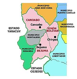
Bejuma bordered to the north by the district Juan José Mora, on the east by the districts of Puerto Cabello, Naguanagua and Libertador, to the south by the state of Cojedes in the Southwest - in an invagination - the districts of Montalbán and Miranda and to the west by the state of Yaracuy.
Administrative divisions
The municipality (district) Bejuma divided into three parroquias:
Economy
The population lives from agriculture and livestock. There are grown and bred cattle, pigs and poultry oranges, lemons, grains, legumes.
Celebrations
The traditional foundation festival is held annually on 18 September. In addition, there are regular celebrations in honor of Saint Raphael on October 24.


