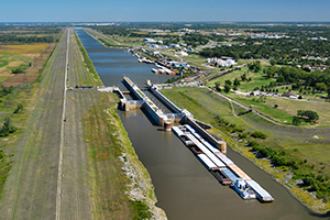
Chain of Rocks Lock
Chain of Rocks Lock ( Chain of Rocks Lock, also known as Locks # 27 ) is the lowest of 29 locks on the upper Mississippi and the only one below the Missourimündung. The lock is located on the Chain of Rocks Canal, the one not navigable section, the " Chain of Rocks " (Eng.: Rock chain), bypasses in the main channel of the Mississippi. Built in 1947-1964 by the United States Army Corps of Engineers building is located between Granite City and Madison in both sides of the channel located in Madison County Illinois. The lock is located in the Metro - East called the eastern part of the metropolitan area of Greater St. Louis the city of St. Louis in neighboring Missouri.
Chain of Rocks
A few miles below the mouth of the Missouri, between the north-eastern parts of the city of St. Louis and the Madison County, Illinois, is a non- navigable portion of the Mississippi. A group of rocks, Chain of Rocks, is strong at low water rapids and thus an obstacle to the navigation.
To this natural obstacle more rocks were still piled up, so a kind of natural defense arose. By this partly natural and partly artificial damming of water sufficient for the navigation above this point, the water level could be achieved.
Channel, and sluice
The Chain of Rocks Canal opened in 1953 begins immediately below the Missourimündung and leads over 13.5 km through the Madison County in Illinois.
At the southern end of the canal is the Lock. This consists of two chambers, the 365.8 m long main chamber and the 182.9 m long second lock chamber. The width is 33.5 m each.


