Has District
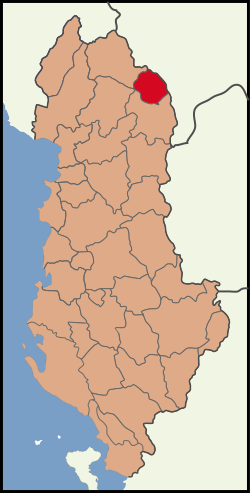
The Circle Has (Albanian: . Rrethi i Hasit respectively Has / Hasi ) is one of the 36 administrative districts of Albania. The circle with an area of 374 km ² belongs to Qark Kukes. It has 16,790 inhabitants ( 2011). Was named the county after the hill country of Has ( Malësia e Hasit ). Capital is the town of Kruma.
The Circle Has is very remote in the north- east of Albania on the border with Kosovo. As the Great Powers in 1913 the border of Albania regulated, they cut through the hill country by Has that lies between the current flowing to the south the White Drin and the current flowing to the west united Drin. When the communists after the Second World War sealed off the border, the traditional economic, family and cultural relations of the inhabitants were interrupted in the eastern part of the Has- highlands to Kosovo. The main markets of Prizren and Gjakova were no longer accessible.
Hill Country Hat is very isolated, sparsely populated and poor. The region is not particularly fertile, which is why it is also called Has i Thate ( dry Has ). From the westernmost to the easternmost point of the circle is the southern boundary of Fierza Reservoir, the jammed Drin formed. On the other side is Kukes. The north-eastern boundary follows the ridge of the Has- mountains, the i Pashtrikut rises to the highest point at 1,988 m Mali. In the northwestern region bordering Tropoja earlier chrome was promoted. The population in the district lives almost exclusively on agriculture. In Has circle there are no minorities. The inhabitants are almost all Sunni Muslims.
The roads in the county Has are very bad. The route from Kukes, Bajram Curri is also claimed by vehicles difficult to happen with all-wheel drive. After the end of the Kosovo war, a new border crossing was opened north of Kruma that connects the circle with Gjakova. In many places the border since the war, during which many Albanian refugees had sought refuge in Has, still mined.


