Kolk
The Kolk, also regional Kulk, is the name for a small depression (called cratering ) on the base of flowing water and a lake that was created in a subsurface erosion of a once or temporarily flooded area. The term is used mostly in the original Low German language area and overlaps in meaning with Gumpe, which is rather common in the southern German -speaking and predominantly relates to the torrents and waterfalls.
- 2.1 Deichkolke
- 2.2 Sumpfkolke
Occurrence and types
On the sole of flowing water
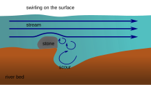
A Kolk (also pothole or swirl pot called ) is an erosion phenomenon in a river bed in the form of a recess in the river bottom or the shore wall. Scours usually develop in hard rock by the Fluvialdynamik of the watercourse. Entrained sand and rock fragments grind from the river bed, causing the river eroded the rock. By swirls and water rollers funnel or cauldron-shaped depressions form. The auskolkende activity of the flowing water is called Evorsion, the initial form of a vortex Kolks niche.
Scour holes are also formed in the surf area on cliff coasts as well as by meltwater from glaciers (see glaciers and glacier mill pot).
In bogs
As Kolk also an accumulation of water in the middle of a rain or boiler Moore's action is referred to, which is also called bog eye. Hochmoorkolke are mostly caused by the acidifying effect of peat moss secondary. Your bank vegetation differs from other structures of the moor and is taken on a more or less powerful peat. Must be distinguished from the smaller hollows.
Behind dykes
Scours caused by lavages after a levee breach; on the coast during storm surges, rivers by flood events. This caused by levee breach scours are also called Bracks and can have great depths.
An underwater structures
Scours also formed at underwater foundations of bridges that span rivers or straits, or of offshore structures such as wind turbines. Especially in shallow, tidally influenced coastal waters leads the flow to scour.
Even on a stranded ship often forms in a very short time Kolk, which to break and thus leads to a total loss before recovery action can be taken. An example is the loss of Fides in 1962 in the Elbe estuary.
Behind weirs
Especially deep scour holes are behind weirs. In order to prevent major erosion, so an attached stilling basin is created behind the dam usually.
Geographical individual objects
Deichkolke
The Larrelter Kolk at Emden was taken at the Christmas flood of 1717, which broke through the dike at great length. The water surface newly formed had the dimensions of 500 x 100 meters and was 25 feet deep. Despite the restoration of the broken dyke it came again in 1721 to a levee breach that left more scours 15 to 18 meters depth. 1825 was taken at the February flood near Emden Kolk from 31 meters depth. The soil was further washed inland from here up to five kilometers.
Sumpfkolke
The buildings of the Museum Island in Berlin were built from 1830 through glacial scours the Berlin glacial valley. The filled with sump pits were already blowing during the ice age with several meters thick sand layers sufficiently solidified to support vegetation and later settlements. Thus, the scour holes remained hidden to the ground investigations for the museum. Parts of the museum buildings were then built up to 20 meters deep -reaching wooden stilts to reach solid ground.


