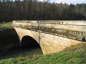
Montigny-lès-Cherlieu
Montigny- lès- Cherlieu is a commune in Haute -Saône in the Franche -Comté.
Geography
Montigny- lès- Cherlieu situated at an altitude of 250 m above sea level, 7 km west-southwest of Jussey and about 32 km northwest of the town of Vesoul (air line). The village is located in the northwestern part of the department, west of Saônetals, on the northern flank of the Ougeotte, at the edge of the heights of Cherlieu.
The area of 20.98 km ² municipal area includes a portion of the undulating countryside to the west of the upper Saônetals. From west to east the area is crossed by the valley of the Ougeotte that provides for drainage Saône. The flat alluvial plain is usually less than 500 meters wide and is on average 235 m. The valley is flanked on both sides by the hills which form the eastern edge of the plateau of Langres. These are subdivided by the Taleinschnitte different streams of Ougeotte: lead from the north of the Ruisseau le Saupiquet ( western border ) and the Ruisseau de Couaz ( eastern boundary ), south of the Ruisseau de Cherlieu.
North of the Ougeotte Valley ranges of communal land to a predominantly agricultural plateau with the ups Les Perrières (308 m) and Côte d' Enfer (302 m). To the south of the valley there are large forests: Bois de Montigny (342 m) and Forêt de Cherlieu, in the 369 m, the highest elevation of Montigny- lès- Cherlieu is achieved. Between these forest heights the valley of the Ruisseau de Cherlieu is sunk, in which the former monastery is located. About the trough of Bougey the community area extends further south to the Grand Bois. These heights consist of alternating layers of sandy- marly and calcareous sediments of the Lias ( Lower Jurassic ) in geological- tectonic terms.
At Montigny- lès- Cherlieu heard the settlement Cherlieu (270 m) at the same creek in the heights of the Forêt de Cherlieu. Neighboring communities of Montigny- lès- Cherlieu are Vitrey -sur -Mance and Saint- Marcel and Jussey in the north, Bougey in the east, Oigney, Melin and Preigney in the south and Chauvirey -le- Vieil and Chauvirey -le- Châtel in the West.
History
The origin of the settlement of the area formed a small priory of St. Anthony Order, which is mentioned in 1127. At this point, Bernard of Clairvaux founded in 1131 the Cistercian monastery Cherlieu whose monks reclaimed the area under cultivation. The Gran Gien the monastery belonged to the homestead Marlay (already mentioned in documents in 1127 ) and the mill Agneaucourt at the Ougeotte.
Montigny is assigned as parish since the 12th century. In the Middle Ages the village belonged to the Free County of Burgundy and in the territory of the Bailliage d' amont. Still in the first half of the 12th century came Montigny in the possession of the monastery Cherlieu and informed from now on its destiny. From 1437 to 1439 Montigny was plundered and devastated by the Ecorcheurs. For further destruction occurred in 1569 by the troops of the Duke Wolfgang of Pfalz- Zweibrücken and during the Thirty Years' War ( 1636). Together with the Franche -Comté reached Montigny- lès- Cherlieu with the Peace of Nijmegen in 1678 definitively to France. Since the time of the French Revolution were Montigny- lès- Cherlieu and Cherlieu a common community.
Attractions
The church of Notre -Dame de l' Assomption in Montigny was extensively rebuilt in 1854, in a historic Romanesque- Byzantine style. The belfry of the earlier building of 1752 was maintained. For the valuable interiors include the richly carved altar, the pulpit (17th century) as well as paneling, paintings and statues from the 18th century. A little above the village stands the statue of the Virgin (1857 ), which was built for the sparing of the place of the cholera epidemic in 1854. In various homes of Montigny- lès- Cherlieu sculpted stones of the former monastery Cherlieu were used. In the center there is a roofed round wells.
Additional area attractions include the remains of the monastery Cherlieu that are as a monument historique classified. These include a high piece of wall of the transept (13th century), convent buildings from the 17th and 18th century and remains of the cloister. A Calvaire dates from the 17th century. The obtained today building the homestead Marlay were built in the 16th century.
Population
With 191 inhabitants ( 1 January 2011) Montigny- lès- Cherlieu one of the small towns in the Haute- Saône. After the population had decreased significantly in the first half of the 20th century ( in 1886 663 people were still counted ), only small fluctuations were recorded since the early 1990s.
Economy and infrastructure
Montigny- lès- Cherlieu was until well into the 20th century a predominantly by agriculture (crops, orchards and livestock ) and forestry embossed village. Today, there are some establishments of local small businesses, including one company in the construction industry. In recent decades the village has been transformed into a residential community. Many workers are therefore commuters who engage in the larger towns in the vicinity of their work.
The village is situated away from the larger passage axes on a secondary road that leads from Jussey after Chauvirey -le- Châtel. Further road links exist with Vitrey -sur -Mance and Saint- Marcel, Bougey and Preigney.
Personalities
- Thomas Gousset, Cardinal and French theologian
- Georges Cogniot, French writer and politician


