Tirana District
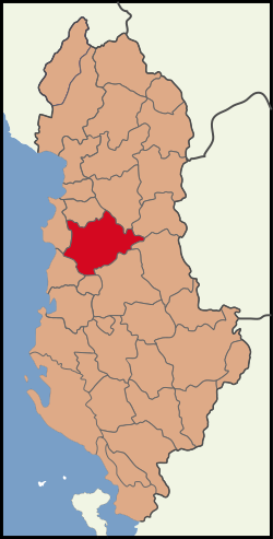
The circle Tirana (Albanian: Rrethi i Tiranës ) is one of the 36 administrative districts of Albania. The circle with an area of 1,238 km ² part of Tirana County. He has about 687 123 inhabitants ( 2011). It was named after the provincial capital Tirana District, which is also the capital of Albania.
Geography
The circle Tirana can be broadly divided into three geographic regions: A plane that extends from the southern outskirts of Tirana to the north- west towards the Adriatic sea, the hills to the west and south of it and the east adjoining the plains and the hill country Skanderbeggebirge.
The level at Tirana is alluvial deposits of the rivers emerging from the mountains Zeza, Tërkuza, Tirana ( Lumi i Tiranës ) and Lana together to the north constitute the Ishëm. Together with the city of Tirana, on the edges of slowly increasing the level in the hills, the area is one of the regions of the country that have experienced the greatest change in the years of transition since the collapse of communism. Tirana became a vibrant city with 418 495 inhabitants ( 2011 census ), and many new buildings. The city expands, more and more of the surrounding region. In particular, along the road to Durres, which crosses the plane at its southern edge, numerous service businesses have been: Albania Coca -Cola factory made the beginning, and soon after, why settle auto companies, forwarders and wholesalers, other factories and shopping malls along. Along the road to the north on the eastern edge of the plain, there are particular construction companies and building material suppliers. Tirana has grown together with all its neighboring communities: on the north- western outskirts are around the place Kamza slums emerged, where have settled thousands of refugees from the country of Albania north. These slums document the conversion of the region particularly dramatic, but the population has Kamzas tenfold in the 1990s and is today 66 841 inhabitants ( 2011 census ). Other places have undergone great changes - so count Tirana neighboring communities Kashar in the West with 43 353 inhabitants ( 2011 census ) and Pashkuqan in the north with 37 349 inhabitants ( 2011 census ), now one of the ten most populous municipalities in the country. The two neighboring communities in the south and east, Farka ( 22 633 inhabitants) and Dajt ( 20 139 inhabitants), are among the largest municipalities of Albania ( 2011 census ).
In the northwest of the circle Tirana belonging part of the plane of the Tirana airport, but its terminal buildings are already in the north adjacent district of Kruja. Apart from these main routes, the level is still important agricultural region. In Valias east of the airport earlier stone coal was mined.
The hill country blocks the direct access of Tirana and the northern plain to the sea and Durres. The long northern foothills Kodra e Gjatë ( long hill ) west of Tirana reaches a height of 491 müa. He flattens northward from getting further and runs most recently as pointed cape Kepi i Rodonit approximately 50 kilometers northwest of Tirana from the sea. When Vora the hills forming a passage of less than 60 m in height. Here happen railway, highway, road, power line and formerly an irrigation channel speakers call. Further south stands the coming of the mountain river in a valley ores broad bottomed through the hills. South of the ores, the Kodrat e Krabës extend ( Krraba Hill ), the win against South continues in height (up to 932 müa ). They represent a natural barrier between Tirana and Elbasan in Shkumbin Valley and only be crossed at a point close to the highest point of a road.
In the mining town Krraba where coal is extracted, the hills gradually changes into mountain country. To the north, the difference is abrupt: the mountains of Kruja chain rise steeply out of the plane: The tip of the DAJTI ( 1613 müa ) is less than ten kilometers from the center of Tirana. Together with the south Priska Mountain ( 1,353 m) is the DAJTI the core zone of DAJTI National Park with an area of 29 384 hectares, which includes not only parts of the Kruja chain, but practically the whole mountainous hinterland of the circle. The Kruja chain is regularly traversed by deeply incised canyons: all rivers cross extending in a north-south direction of the mountain chain from east to west. On the northern county boundary the Tërkuza is jammed in such a gorge to Bovilla Reservoir, the largest water reservoir of Tirana. The reservoir with a volume of 80,000,000 cubic meters has been in operation since December 1998. Other canyons form of Tirana River north of DAJTI and ores south of Priska Mountain. Behind this mountain range is very secluded mountain land. The eastern boundary of the circle is formed by a further high mountain range, whose highest point, Mount Holy Evangelist Noi i Madh (1848 müa ), at the same time is the highest point in the county. This forms the watershed between the valley of the Mat and the border of the circuit Mat Another part of this mountain range are the Mali me Gropa (mountains with holes), a barren karst landscape that is traversed by numerous sinkholes and reminiscent of the lunar surface. Its highest point is the Maja e Miçeku të Shënmërisë with 1828 müa.
History
Although the city of Tirana was founded only in 1614, the region has a very long history: the first traces of settlement by humans date back to the Paleolithic. In Rrëza e DAJTIT at the foot of Dajtis and in great Pëllumbas Cave in the ores Gorge Gryka e Skronës many relics have been discovered from this and later periods. From the Iron Age fortress Kalaja e Dorzit comes on a 477 m high hill about 20 km south-west of Tirana. The protection system is surrounded by a 300 meter-long stone wall. Another fortress dates from the Illyrian period ( 3rd and 2nd century BC ): The Persqop Castle is located east of the village Petrela on a mountain. Get is only a 30 m long and 6 m high Fragment of stone wall. In the castle, a grave was discovered.
In late antiquity and the Middle Ages many castles were built, which should control and protect the region and the various trade routes. In Tirana routes crossed from north to south with those who joined the coast in the west to the central areas of the Balkans. The most famous and most accessible for visitors castle is that of Petrela, which was part of Skanderbegs defense system in the 15th century. The castle is situated on a pointed hill west of the village, all the ores Valley overlooking. The first fortifications thought to date back to the 3rd century. In the 9th century, the plant was expanded and served the numerous local rulers of central Albania as a base. Later was added in an external enclosure, which provided protection to a small but well-fortified castle on the top. To Skanderbegs times she was part of a defense system, warning signals could be passed from one castle to the next.
On the western slope of the Dajtis to around 1200 müa lie the remains of DAJTI Castle, which was built in the 4th century and allowed for control over vast areas. Another fortress is situated on the north-west foot of the village Dajtis Tujan. This castle dates from around the same time and controlled the leading through the canyon of Tirana River Street to the east. In the 6th century Justinian built a fortress in the city center today Tirana - in contrast to all other systems, this is not on a hill, but in the plane. Still a little older mosaic remains of an early Christian church in Tirana. At the western edge of the plain of Tirana watches today the Castle of Preza, probably built first by the Ottomans in the 15th century. Other fortifications were located at Ndroq at a narrow place to the west located in the Valley ores, in Lalmi on the southwestern outskirts of Tirana, on the northern bank of ores and in the Holy Evangelist Gjergj in the east of the circle on the road to Mat and Dibra.
At the village Vrap in the southwest of the district was in 1902 a farmer in his field a gold and silver treasure, which included, among other nine vessels of gold, 30 silver vessels and parts of Kleidungsaccesoires. The objects were made in the 8th century by the Avars. 39 pieces of which are now in the Metropolitan Museum of New York.
During World War II it was in the hills and mountains around Tirana repeatedly to secret meetings of the resistance fighters. In the village Peza southwest of Tirana, a non-partisan National Liberation Movement was launched on 16 September 1942 on the so-called Conference of Peza. In August 1943, communists and nationalists agreed in the village Mukja north of Tirana on further cooperation and the structures of resistance.
Traffic
Tirana was founded at the crossroads of ancient trade routes. Today Tirana is itself the center, from where major transport links run away, but only in three directions. The road to the east is now only an insignificant, only the local utility serving side road in poor condition. Otherwise Tirana is now a major transportation hub with road links to the north, south and west, and Zugsanbindung and the only international airport of the country. Apart from these axes but many areas of the district are remote and difficult to access.
Highway and railway leaving the boiler from Tirana in a northwesterly direction. Along this axis after Durrës an almost unbroken chain of services, trade and industrial production plants have settled in recent years, including the shopping centers Qendra Tregtare Univers and City Park. Another transport hub is Vora halfway between Tirana and Durres. Here the road goes off to northern Albania (part of A1) as well as the railway line to Shkodra.
Other important roads leading from Tirana directly to the north, on a more southerly route to Durres and as SH3 on the Krraba Pass to Elbasan. The road network in the district is constantly expanded to meet the ever- increasing traffic requirements. The end of 2006 the road from Vora was renewed north to Fushë - Kruja. For the connection to Elbasan a new A3 motorway east of the existing pass road is built, the core of which is 2200 meters long Krraba tunnel. At the same time a new bypass road is built, which relieves the city center. The airport, the new terminal was opened in early 2007, also received a new connection. The airport must be removed due to overload again, the construction work has already begun. Only the connection through the mountains to the east has not much more than an idea.
The traffic has become in Tirana to a versatile problem. While in 1991 no private car ownership was allowed, now tens of thousands of cars clogging the streets of the city. In addition to the storage through the many cars on narrow streets and the smog caused by them is a serious problem: Many cars are older models and the exhaust gases drawn from the boiler of Tirana only poorly. As relief, the construction of a rapid transit is provided to the airport. Public transport is handled almost entirely by buses.


