Astet
Astet is a municipality with a population of 40 (as of January 1, 2011 ) in the department of Ardèche, which belongs to the French region of Rhône -Alpes. The inhabitants are called Asténiens.
Geography
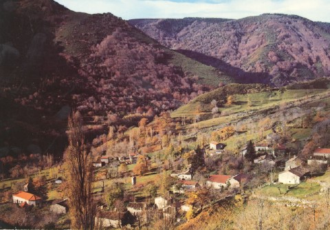
Astet located at the beginning of the carrying of the Ardèche valley in the highlands of the Cevennes, in the south of the department. The municipality borders the neighboring municipality Lanarce. The next largest city is Aubenas 30 kilometers from the east. You can reach the place via a connecting route with the national road ( 1266 meters high) to the Col de la Chavade. Also, the flow Espezonette crosses the municipality. The village itself is situated on a mountain slope and is one of the snowiest in the region. The landscape is dominated by cliffs, gorse and Farnsträuchern. Astet refuge is large boar families.
History
Astet had been only community in the Middle Ages a short time and existed until 1790. Subsequently the place was part of the neighboring municipality Mayres. On 12 July 1907, the place was merged with the neighboring village Mares for today's community Astet.
Population Development
Attractions
Tourism is very important for the community Astet. It is part of the Regional Natural Park of Monts d' Ardèche. Around the village there is an approximately 2000 hectares of forest area in the middle of the Cevennes. At higher elevations, there are pastures and the ski station Croix -de- Bauzon. In the place which is the restaurant La Burle. The source of the Ardèche is located in a small forest with the name Mazan. The Massif du Boizon is happening on a hiking trail, which will be held also at Les Issartoux and Bel Air, Cham Longe.
Astet | Barnas | Chirols | Fabras | Jaujac | Lalevade d'Ardèche | La Souche | Mayres | Meyras | Pont -de- Labeaume | Prades | Saint- Cirgues -de- Prades | Thueyts
- Municipality in the department of Ardèche
- Place in Rhône -Alpes


