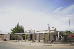
Bethanie, Namibia
Mayor / in: ? (RDP )
Chief Executive Officer:
Last election: 2010
Next election: 2015
Address of the city administration:
Geographic coordinates: 26 ° 30'4 .59 " S, 17 ° 9'36 .78" O
Height: 1000
Bethanie ( Afrikaans and officially ) and Bethany ( in German and historically ) is a village in the south of Namibia. It has about 9300 inhabitants, is 1000 meters high and is located near the national road between Keetmanshoop and Lüderitz B4.
History
Bethanie owes origin and name of the London Missionary Society (LMS ), namely by the missionary Henry Schmelen. This came in 1815 along with an emigrant from Pella Orlam society over the Orange River and found here " a permanent source, which can not be closed with a stone " - to Khoekhoegowab " | Ui ǂ gandes " and in Afrikaans " Klipfontein " - and good pasture.
Schmelen named the place from now on according to the biblical site was baptized Jesus Christ, Bethany. Here he put up the first built by Europeans stone house in South West Africa, which can be visited even today - the Schmelenhaus of 1815 - and tried to make the Orlam and immigrating Nama ( " Bethanier " ) to settle here and to the Christian faith to convert. 1859, the twin-towered church was built. On May 1, 1883 Bethany became once more historical significance in that Heinrich Vogelsang here with the Orlam Kaptein Joseph Frederiks II the first land purchase contract for Adolf Lüderitz graduated and thus laid the foundations for the later German colony of German South-West Africa.
Today Bethany is a small, but important for the farmers and Nama around supply base in which it except post office and police are all that is needed for daily life.
Local Politics
In the 2010 local elections the following official final result was determined.


