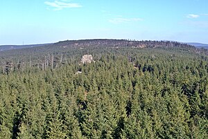
Auf dem Acker
View from the tower of the Hanskühnenburg east
On the field ( the short form field is in use ) in the resin is a maximum of 865.1 m above sea level. NN high mountain ridges of the Upper Harz in the district of Osterode am Harz in Lower Saxony ( Germany ).
Origin of the name
At various points, it is claimed, the name field so can be derived from the Middle High German Agger with the meaning ridge or wall off. Date for this purpose but lacks a sound source. On the other hand, Agger is a Latin word meaning earth dam or embankment, see Agger ( attachment ).
Geographical location
The ridge on the field is located in the Upper Harz. Its high altitude areas are located in the Harz National Park, and the majority of its edges in the Harz nature park. He begins southwest of the mountain at break Stieglitz corner on the main road 242 and extends from there about 13 km south-west direction, which he at first 6 km through more than 800 m above sea level. NN achieved. The extreme southwestern foothills go in Osterode am Harz in the Harz mountains above. Together with the Bruchberg forms of arable arable - breaking mountain massif.
Located northwest of the ridge is the valley of the Söse with the Söse reservoir lake, as well as the places Riefensbeek and Kamschlacken. South of the ridge are the places Lonau and Sieber. At about the middle of the ridge stands at about 811 m altitude, the mountain cottage Hanskühnenburg.
National Park and Nature
The arable parts that are in the Harz National Park, may be entered only on designated trails. There are parts of the comb area from rain Moor between the Hanskühnenburg and Stieglitz corner. This raised bog was largely destroyed by Abtorfung and drainage measures. Peat was still operated until 1970. The leading through the moorland Fastweg was locked mid-1990s, shortly after the founding of the National Park to protect nature.
Geology
The ridge consists largely of field - breaking mountain quartzite.
Cliffs and rocks
On the field there are many cliffs and rocks. The following list is an alphabetic cliffs and rock selection, with - if known - height in meters ( m) above mean sea level ( MSL ) and the respective geographical location ( ⊙ ):
- Goldenkerklippe ( max. 840 m) ( ⊙ 51.733810.4224 )
- Hammerstein cliffs ( max. 780 m) ( ⊙ 51.766710.4503 )
- Hanskühnenburg rocks ( approximately 815 m), on the crest of the Hanskühnenburg ( ⊙ 51.727910.4036 )
- Hanskühnenburg cliff ( approximately 818 m), on the ridge near the Hanskühnenburg ( ⊙ 51.7310.4064 )
- Kanapeeklippe ( max. 750 m ) ( ⊙ 51.726310.3961 )
- Monk cap cliff ( max. 680 m) ( ⊙ 51.74710.4626 )
- Seiler cliff ( approximately 760 m), on the ridge, 1 km east of the coiler head ( ⊙ 51.721310.3838 )
- Sösestein ( max. 730 m) ( ⊙ 51.766510.4523 )
- Sophie cliff ( max. 650 m), below the reel head ( ⊙ 51.715610.3644 )
- Philistine cliff ( max. 640 m), below the reel head ( ⊙ 51.714210.3585 )
- Stollen cliff ( max. 690 m) ( ⊙ 51.727410.4153 )
F1 map with all coordinates of the cliffs and rocks: OSM, Google and Bing
Hiking
At the northeast end of the ridge is the refuge Magdeburg hut and a large car park at Stieglitz corner. From there, two paths lead to the field, which are described in the article Hanskühnenburg closer. From the Hanskühnenburg the Fastweg leads " Nasser way " in a southwesterly direction on the ridge in the direction Osterode. Since the comb is covered only sparsely with blueberries and short stature pines, there are many vantage points with views over the resin and into the Harz Foreland. A stage in the Harz Mountain cottage walkway leads from Lerbach across the field after Sieber.
At the end of the field or are a mountain cottage, a fetlock and two shelters, which are each incorporated into the system of stamp locations of the Harz hiking pin ( in ascending order by stamp desk numbers ):
- Fetlock on shingle head ( about 550 m; ⊙ 51.72304722222210.336375; stamp body No. 143)
- Mountain cottage Hanskühnenburg (approx. 811 m; ⊙ 51.72806944444410.403208333333; stamp body No. 144)
- Morgenbrodt hut at Great weir ( approximately 604 m; ⊙ 51.76254166666710.445791666667; stamp body No. 146)
- Refuge Waidmannsdorfer rest (about 700-710 m above sea level, . ⊙ 51.73211111111110.43175; stamp body No. 148)
Swell
- Topographic map 1:25000, No. 4228 Riefensbeek ( containing the major part of the ridge )
- Topographic map 1:25000, No. 4227 Osterode am Harz ( containing the southwestern foothills )


