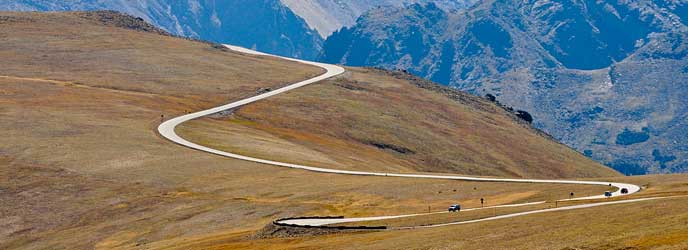
Trail Ridge Road
As Trail Ridge Road, also Trail Ridge Road / Beaver Meadow National Scenic Byway, of the 77 km road section of U.S. Highway 34 in Rocky Mountain National Park between Estes Park and Grand Lake ( Colorado) is called. The road, which was recognized as a National Scenic Byway due to their tourist importance, the highest continuous highway in the United States. Around 18 km are located above the tree line, the highest point of the road is at 3713 meters.
Route Description
From Kawuneeche Visitor Center in the southwest of the park from the Trail Ridge Road to the North through the Kawuneeche Valley. The valley offers numerous starting points for hiking, trail heads, which lead along the Colorado River or on the hills.
After the Colorado River Trailhead, the road rises and opposes the east to the Farview Curve, a popular lookout point from where you have a view on the Kawuneeche Valley and the Never Summer Mountains. After another three kilometers you will reach the Milner Pass, which forms the North American continental divide between the Atlantic and the Pacific.
Shortly after the Alpine Visitor Center can be reached in an easterly direction to the highest point of the road at 3713 meters ( 12,183 feet). Subsequently, the Trail Ridge Road leads down to the east, past the lookouts Rock Cut, Forest Canyon and Rainbow Curve. The winding road ends at Estes Park, where the U.S. Highway 34 and U.S. Highway 36 meet.
In low-lying areas, the road leads through mountain forest of aspen and ponderosa pines. With increasing height of the mountain forest gives way to subalpine vegetation of dense fir and spruce. Above the tree line prevails windy weather. The tree- free environment provides a wide view of the Rocky Mountains.
Genesis
1921 Fall River Road, the first motorable access was opened to the highlands of the Rocky Mountain National Park. However, the single-track road proved to be due to the strong slope ( sometimes up to 16 %) and the tight curves to be unsuitable for motorized traffic.
The National Park Service and the Federal Highway Administration agreed in a row on a new route. Work on the new Trail Ridge Road began in 1929. The first section between Deer Ridge and the Fall River Pass was completed in 1929. The new maximum slope of the road is not more than 7% today. The second section through the Kawuneeche Valley to Grand Lake in the southwest of the park was opened in 1938.
Due to the prevailing climatic conditions, the work could be carried out at the construction of the road only during the summer months between mid-June to mid-October.


