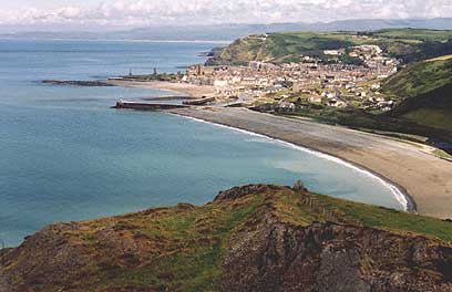
Cardigan Bay
52.521569 - 4.495239Koordinaten: 52 ° 31 ' 18 "N, 4 ° 29' 43 " W
As Cardigan Bay ( Welsh: Bae Ceredigion or Bae Aberteifi ) is called the bay at the northern exit of the St. George's Channel of the Celtic Sea towards the Irish Sea on the west coast of Wales between the Lleyn Peninsula and Pembrokeshire. Its extension is about 100 km in a north-south length and 50 km in depth.
There are various seaside resorts in Aberystwyth, Aberporth, Fishguard, New Quay, Aberaeron, Aberdyfi, Barmouth or Criccieth.
Cardigan Bay has white sand beaches, turquoise, clear waters and places Delphi stocks at New Quay and Llangrannog. Their population is divided into two groups and includes a count by the University of Aberdeen 127 animals.
The vast area of the bay consists of fertile farmland, individual market towns and smaller cities as well as the previously mentioned seaside resorts.
Several major rivers empty into the bay: Teifi, Rheidol, Dyfi, Aeron, and Mawddach.
Until the early 20th century the bay formed the basis of a strong shipbuilding industry. Cardigan, located near the mouth of the Teifi was temporarily a more important port as Cardiff.
The Cardigan Bay will be the site of the legendary sunken Welsh kingdom Cantre'r Gwaelod or Maes Gwyddno, which is often called the " Welsh Atlantis " means.


