Broye-les-Loups-et-Verfontaine
Broye -les- Loups -et- Verfontaine is a commune in Haute -Saône in the Franche -Comté.
Geography
Broye -les- Loups -et- Verfontaine situated at an altitude of 220 m above sea level, 12 km west of Gray and about 33 km northeast of the city of Dijon (air line). The village is located in the extreme west of the département, in the valley of the brook Soirsan.
The area of 7.00 km ² municipal area comprises a section in the rolling countryside of north west of Saônetals. From northeast to southwest, the area is crossed by Soirsan, which provides for drainage to Vingeanne. The valley is on average 215 m and has a width of around 500 meters. It is about 20 m deep sunk into the surrounding plateau. The trough of Broye -les- Loups is used predominantly agricultural. It is in the east of the hill of the Forêt d' Autrey, flanked to the west by the Bois de Lœuilley. To the north, the municipality's area extends into the trough of Verfontaine and on the adjacent heights, which consist primarily of sediments of the Tertiary. With 254 m is achieved at the height at the edge of the forest of Attricourt the highest elevation of Broye -les- Loups -et- Verfontaine.
The double municipality consists of the villages of Broye -les- Loups (220 m) and Verfontaine (241 m), both located in the valley of the Soirsan. Neighboring communities of Broye -les- Loups -et- Verfontaine are Saint-Seine- sur -Vingeanne in the north, Autrey- lès-Gray in the east, Champagne- sur -Vingeanne in the south and Lœuilley and Attricourt in the West.
History
Remains of a Gallo- Roman building evidence of an early settlement of the area. The area around Broye was probably brought under cultivation in the 7th century; documented, however, the place is only around 1200. During the Middle Ages Broye and Verfontaine belonged to the Free County of Burgundy and in the territory of the Bailliage d' amont. The local government had held the Lords of Vergy. Verfontaine came in 1096 was donated to the monastery of Conques and 1120 at Saint Étienne Dijon, who had built here in the 13th century built a chapel ( demolished in the 18th century). The villages were devastated in 1360 by the English. Together with the Franche -Comté reached both villages with the Peace of Nijmegen in 1678 definitively to France. In 1806 merged Broye -les- Loups and Verfontaine to double community. Today Broye -les- Loups -et- Verfontaine is a member of the 14 localities comprehensive community association Communauté de communes des Quatre Vallées.
Attractions
The village church of Broye -les- Loups was built in the 18th century and houses a statue of John the Baptist ( 18th century). From the 19th century the chapel of Verfontaine comes. Also in the 19th century, the covered Lavoir was built by Verfontaine that once served as a laundry and watering cattle.
Population
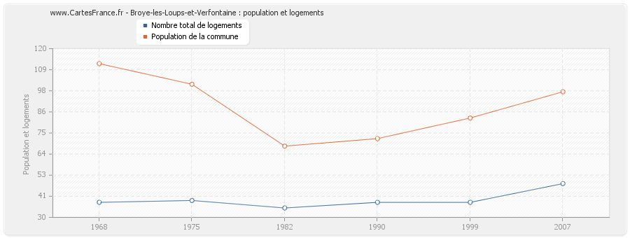
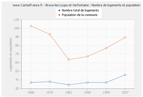
With 105 inhabitants ( 1 January 2011) Broye -les- Loups -et- Verfontaine one of the smallest municipalities in the department of Haute- Saône. After the population had decreased significantly in the first half of the 20th century (1881 250 people were still counted ), a slight population growth was recorded since the early 1980s again.
Economy and infrastructure
Broye -les- Loups -et- Verfontaine is still a predominantly by agriculture (crops, orchards and livestock ) embossed village. Outside of the primary sector, there are few jobs in town. Many workers are therefore commuters who engage in the larger towns in the vicinity of their work.
The village is situated away from the larger passage axes on a secondary road, leading from Autrey- lès-Gray to Champagne -sur -Vingeanne. Further road links exist with Poyans and Lœuilley.

