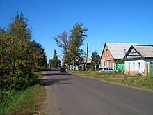
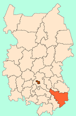
Cherlak, Cherlaksky District, Omsk Oblast
Tscherlak (Russian Черлак ) is an urban-type settlement in the Omsk Oblast (Russia) with 10,980 inhabitants (as of October 14, 2010 ).
Geography
The settlement is located in the West Siberian Plain, about 130 kilometers southeast of the Oblasthauptstadt Omsk on the right, higher banks of the largest Ob- Irtysh tributary.
Tscherlak is the administrative center of the homonymous Rajons Tscherlak.
History
The place was built in the 1720s as Tscherlakski Forpost ( " Tscherlaker outposts " ) in the course of that boundary line of the Russian Empire established among those not yet colonized steppes of present-day Kazakhstan. Here Cossacks were resettled from the areas around Tara and Tobolsk, and later from Central Russia banned farmers.
1925 Tscherlak administrative center of a Rajons 1947 urban-type settlement.
Demographics
Note: Census data
Culture and sights
In Tscherlak there since 1985, a museum of local history.
Economy and infrastructure
Tscherlak is the center of an agricultural region with companies in the food processing industry.
By Tscherlak the highway leading M38 (also European Route 127), the right Irtyschufer continues in the direction of Pavlodar and Semipalatinsk from Omsk upwards to the Kazakh border and from there. About this road and the nearly 40 km from railway station Tscherlak can be reached at the "middle -Siberian Railway " Omsk - Karassuk - Srednesibirskaja, which runs to more than 100 kilometers, across the territory of Kazakhstan from here. The closer to the settlement stations Talapker and Ljubowka are accessible only by car ferry, since there exists a road bridge neither Tscherlak, nor even between Omsk and Kazakh border.


.svg/115px-Flag_of_Cherlaksky_rayon_(Omsk_oblast).svg.png)


