Bangalore Rural district
The District Bangalore Rural ( Kannada: ಬೆಂಗಳೂರು ಗ್ರಾಮೀಣ ಜಿಲ್ಲೆ " Bangalore - land") is a district of the Indian state of Karnataka. Council is based in Bangalore (Bengaluru ), but which does not itself part of the district.
Geography
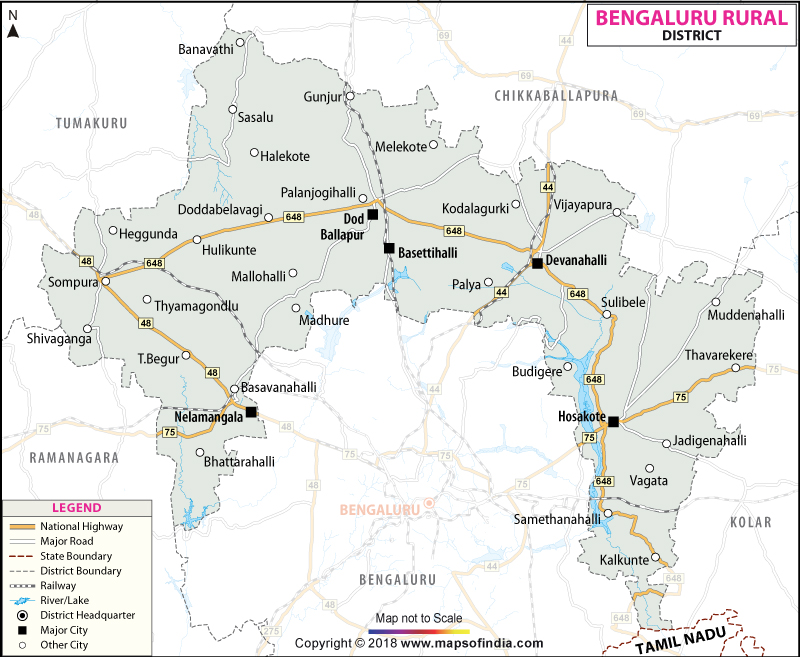
The District Bangalore Rural is located in the southeast of Karnataka and covers an area north and east of Bangalore (Bengaluru ), the capital of Karnataka and the third largest city of India. Neighboring districts are Bangalore Urban in the south, in the southwest of Ramanagara, Tumkur in the west Chikballapur in the northeast, Kolar in the east and Krishnagiri in the south. The latter already belongs to the neighboring federal state of Tamil Nadu.
The area of the district of Bangalore Rural is 2,239 square kilometers. This makes it to Bangalore Urban district of Karnataka is the second smallest. The district area belongs to the southern part of the Deccan Plateau and consists of a plateau with an average altitude of 600 to 900 meters above sea level. In contrast to the neighboring district of Bangalore Urban, Bangalore is largely urbanized, the strong growth, the District Bangalore Rural is rural.
The District Bangalore Rural is divided into four taluks Devanahalli, Dodballapur, Hoskote and Nelamangala.
History
The district Bangalore Urban district goes back to Bangalore. This was one of the districts of the Princely State of Mysore during the British colonial period. After the independence of India Mysore took place in 1949 following the Indian Union. 1956, the district had to the Bangalore to the language boundaries of the new State of Mysore Kannada (1973 renamed Karnataka ), whose capital was now Bangalore. The District Bangalore Rural arose in 1986 when the former district of Bangalore was divided into the districts of Bangalore Urban and Bangalore Rural. Originally comprised Bangalore Rural an area almost completely enclosed the district Bangalore Urban. 2007 but split in the southwestern part of the district as a separate district from Ramanagara.
Population
According to the 2011 census of District Bangalore Rural has 987 257 inhabitants. The population is the second lowest of all the districts of Karnataka, the population density is 441 inhabitants per square kilometer, but above the average for the state (319 inhabitants per square kilometer). The district is defined clearly rural: only 27.1 percent of the population lives in cities. The degree of urbanization is thus lower than the average of Karnataka ( 38.6 per cent). While the metropolitan Bangalore experiences a significant population growth, the growth rate in the rural district Bangalore Urban is 16.0 percent 2001-2011 barely higher than the average for the state ( 15.7 percent). The literacy rate is slightly higher than the mean value of the state ( 75.6 percent ) and total India ( 74.0 percent) with 78.3 percent.
The population of the old district of Bangalore Rural (including the District Ramanagara ) prepared in accordance with the 2001 census Hindus with 90.0 percent, a large majority. For Islam is a minority known by 9.1 percent.


