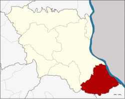
Don Tan District
Amphoe Don Tan ( Thai อำเภอ ดอนตาล ) is the southernmost district ( Amphoe - administrative district ) of the province of Mukdahan. The Mukdahan Province is located in the eastern part of the Northeast region of Thailand, the so-called Isaan.
Geography
Adjacent counties and regions are (from south-east clockwise): Amphoe Chanuman the province Amnat Charoen, Amphoe Loeng Nok Tha in the province of Yasothon, and Amphoe Mueang Mukdahan Nikhom Kham Soi and the province of Mukdahan. To the east on the other bank of the Mekong, Savannakhet Province of Laos is located.
The main river of the district is the Mekong River.
History
Originally Don Tan was a commune ( tambon) of the district Mueang Mukdahan Nakhon Phanom province. In 1963, Don Tan to a sub-district ( King Amphoe ), 1974 promoted to a Amphoe. When in 1982 the new Mukdahan Province was created, Don Tan was one of the counties from which the new province was originally.
Management
Amphoe Don Tan is divided into seven subdistricts (tambon ), which continued in 62 village communities ( Muban ) are divided.
Don Tan itself has a small-town status ( thesaban tambon), it consists of parts of the tambon Don Tan.
In Amphoe Don Tan, there are two small towns ( Tambon thesaban ):
- Don Tan ( Thai: เทศบาล ตำบล ดอนตาล ) consists of parts of the tambon Don Tan,
- Ban Kaeng ( Thai: เทศบาล ตำบล บ้าน แก้ง ) consists of the whole tambon Ban Kaeng.
In addition, there are six " Tambon Administrative Organizations" (TAO, องค์การ บริหาร ส่วน ตำบล - administrative organizations) in the district.


/Hin%252520Thoep%252520rocks/thumbs/K1130004.jpg)


