Aksu Prefecture
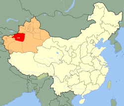
The county of Aksu ( Turkish " white water") is located in the Xinjiang Uygur Autonomous Region of the People's Republic of China. It has an area of approximately 132,500 km ² and 2.19 million inhabitants ( end of 2003). Capital of the district of the independent city of Aksu Aksu on the river.
Administrative divisions of the district of Aksu
The county of Aksu consists of an independent city and eight districts:
- City Aksu (阿克苏 市Akesu Shì ), 14,668 km ², 570,000 inhabitants (2003 );
- Circle Aksu Konaxeher (温宿 县wensu Xiàn ), capital: greater community Wensu (温宿 镇), 14,309 km ², 220,000 inhabitants (2003 );
- Kuqa County (库车 县kitchen Xiàn ), capital: greater community Kuqa (库车 镇), 14,522 km ², 410,000 inhabitants (2003 );
- Circle Xayar (沙雅县Shāyǎ Xiàn ), capital: greater community Xayar (沙雅 镇), 31,868 km ², 220,000 inhabitants (2003 );
- Circle Toksu (新 和 县Xinhe Xiàn ), capital: greater community Toksu (新 和 镇), 5821 km ², 140,000 inhabitants (2003 );
- Circle Bay (拜 城县Baicheng Xiàn ), capital: greater community Baicheng (拜 城镇), 15,889 km ², 200,000 inhabitants (2003 );
- Circle Uqturpan (乌什 县wushi Xiàn ), capital: greater community Wushi (乌什 镇), 9012 km ², 190,000 inhabitants (2003 );
- Circle Awat (阿瓦提 县Āwǎtí Xiàn ), capital: greater community Awat (阿瓦提 镇), 13,976 km ², 210,000 inhabitants (2003 );
- Circle Kalpin (柯坪 县Keping Xiàn ), capital: greater community Kalpin (柯 坪镇), 8918 km ², 40,000 inhabitants (2003 ).
Neighbors
Aksu is bordered to the east by the Mongolian Autonomous County Bayingolin, on the northwest by Kyrgyzstan and Kazakhstan, to the south by the Government District Hotan ( Khotan ), on the southwest by the administrative district of Kashgar and the Kyrgyz Autonomous County Kizilsu and to the north by the Kazakh Autonomous County Ili.
Ethnic structure of the population of the district of Aksu (2000)
At the census in 2000 2.141.745 inhabitants were counted in the district of Aksu ( population density 16.16 inhabitants / km ²).
History
Previously Aksu was an ancient Buddhist kingdom that was located on the Silk Road near the Taklamakan Desert in the Tarim Basin. The pilgrim Xuanzang ( 7th century ) noted that there were ten Buddhist monasteries in the UK and over 1000 monks. He said that the Kingdom 600 Li from east to west and 300 Li from the north measured to the south. He also stated that the cloth, which was produced in the region was as a commodity for the riparian states, such as the Kingdom of Kashi, is important.
Literary source
- The Chinese Book of Han writes about the Kingdom.
41.221180.2469Koordinaten: 41 ° 13 ' N, 80 ° 15' O


.png)

