Celles-sur-Plaine
Celles- sur -Plaine is a commune with 855 inhabitants (as of January 1, 2011 ) in the department of Vosges in the Lorraine region. It belongs to the Canton of Raon- l'Étape in the arrondissement of Saint- Dié -des-Vosges and is a member of the department of inter- municipal association ( Communauté de communes ) Vallée de la Plaine.
Geography
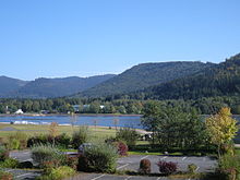
Celles- sur -Plaine is a commune in the Vallée de la Plaine in the Vosges. It is flanked by a Forêt domaniale of élieux and the Forêt de Celles domaniale settlement on the Meurthe Creek Plaine. The river forms the border with the department of Meurthe -et -Moselle. The community is served by the Department of Road 392a to the national road network. Southwest of the village there is the Lac de Celles- sur -Plaine, an artificial lake in 1983. Two striking elevations are located in the municipality: the Pain de Sucre ( 671 m) and the Tête du Coquin ( 837 m).
History
Celles- sur -Plaine was from 1594 the County of Salm and 1710-1790 the Duchy of Lorraine and the Principality of Salm. Then the settlement became part of the district of Saint- Dié.
In Celles -sur -Plaine in 1950 was the meeting place for the group Nicolas Bourbaki.
The Lac de Celles- sur -Plaine was created in 1983 in connection with the Lac de Pierre- Percée. It serves to regulate the Moselle and thus the cooling of the nuclear power plant Cattenom.
Demographics
Lorraine typical row of houses
Lac de la Plaine


