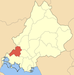
Arta (regional unit)
Arta (Greek Άρτα; Albanian Qarku i Artes) was until 2010 one of the four regional districts of the Greek region of Epirus. It was built after the annexation of southern Epirus to Greece in 1882 as a prefecture and 1915 extended to the areas west of the Arachthos. With the administrative reform in 2010 he lost the prefecture status; Since then, the area apart from the allocation of seats in the Regional Council has no political significance. Namesake and the capital is the town of Arta.
Location and geography
The area is north of Ambracian Gulf and is surrounded by mountains in the northeast, by leading a single road link over the Pinios Valley in the region of Thessaly. In the west and north borders the Arta areas of regional districts Preveza and Ioannina, Thessaly to the east and to the south by Aetolia - Acarnania. The eastern border is the River Achelous, and the western boundary of the river Louros.
The highest point of the area is the Athamanon ( Tzoumerka ) on the north-eastern boundary with a height of 2393 m above sea level. NN. The Athamanon and the associated running from north-north- west to south-southeast mountain range belong to the southern Pindos Mountains. The Athamanon represents the watershed between the catchment area of the Arachthos in the west of the mountain range and the Achelous in the east of the mountain range Represents the area Artas part of the water catchment area of Arachthos. This is also the largest and longest river, followed by Louros River on the western border of the area.
Structure
The regional district comprises the municipalities of Arta Arta, Georgios Karaiskakis, Kendrika Tzoumerka and Nikolaos Skoufas.
Traffic
The main mode of transport in both the public as well as in economic and private transport is road traffic. The area has a network of well-maintained roads, especially in the flat part around the Ambracian golf around. The main direction of traffic flow is from the north ( Ioannina) to south ( Agrinio, Missolonghi ).
- National Road 5 ( European route 951)
- National Road 42
- National Road 30
The area has neither an international airport nor a port or a railway connection. As part of the planning of the rail part of the Trans- European Transport Networks ( TEN), however, a railway connection via the route Messolonghi, Agrinio, Amfilohia, Arta, Ioannina, Igoumenitsa is provided. The project is not secured very controversial and both its financing and implementation due to its high cost due to the topography.


