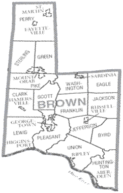
Brown County (Ohio)
Brown County is a county located in the state of Ohio of the United States. The administrative headquarters ( County Seat) is Georgetown.
Geography
The County is located south-southwest, Ohio, adjacent to Kentucky and has an area of 1283 square kilometers, of which nine square kilometers of water surface. It is bordered clockwise to the following counties: Clinton County, Highland County, Adams County, Mason County (Kentucky), Bracken County ( Kentucky) and Clermont County.
History
Brown County was formed on December 27, 1817 from parts of Adams County and Clermont County. It was named after Jacob Brown, a Major General in the British -American War, was wounded at the Battle of Lundy 's Lane.
Demography
1900-1990 2000
According to the census in 2000 lived in Brown County 42 285 people in 15,555 households and 11,790 families. The population density was 33 people per square kilometer. The racial the population was made up of 98.08 percent White, 0.92 percent African American, 0.18 percent Native American, 0.13 percent Asian, and 0.08 percent from other races; 0.60 percent were descended from two or more races. 0.44 percent of the population were Hispanic or Latino of any race.
Of the 15,555 households out of which 37.1 percent have children under the age of 18 living with them. 61.3 percent were married couples living together, 10.0 percent were single mothers, 24.2 percent were non-families, 20.2 percent of all households and 8.5 percent had someone living alone at the age of 65 years or older. The average household size was 2.69 and the average family size was 3.09.
Based on the county the population was spread from 27.6 percent population under 18 years, 8.1 percent between 18 and 24 years, 30.3 percent between 25 and 44 years, 22.4 percent between 45 and 64 years and 11.6 percent were 65 years old or older. The average age was 35 years. For every 100 females there were 96.8 males. For every 100 females age 18 and over, there were 94.8 men statistically.
The median income for a household was $ 38,303, and the median income for a family was $ 43,040. Males have a median income of $ 32,647, women $ 22,483. The per capita income was $ 17,100. 8.8 percent of families and 11.6 percent of the population lived below the poverty line. Of these, 15.2 percent were children or adolescents under age 18 and 9.4 percent of those 65 years.
Places in Brown County
Villages
- Aberdeen
- Fayetteville
- Georgetown
- Hamer Ville
- Higginsport
- Mount Orab
- Ripley
- Russellville
- Sardinia
- St. Martin
Townships
- Byrd Township
- Clark Township
- Eagle Township
- Franklin Township
- Green Township
- Huntington Township
- Jackson Township
- Jefferson Township
- Lewis Township
- Perry Township
- Pike Township
- Pleasant Township
- Scott Township
- Sterling Township
- Union Township
- Washington Township


