Beauménil
Beauménil is a commune with 122 inhabitants (as of 1 January 2011 ) in the department of Vosges in the Lorraine region. It belongs to the district Epinal, founded the canton of Bruyeres and to the 2002 Local Government Association Vallée de la Vologne.
- 3.1 Hermit Cave
- 4.1 Road Access
Geography
The municipality is located in the Vosges Beauménil at an altitude of 430 m above sea level, about halfway between Epinal and Saint- Dié.
The area of 3.3 km ² municipal area comprises a portion of here about 1000 m wide valley of the river Vologne, which forms the northern boundary of the municipality. In the Vologne lead to height Beauménil the nine tributaries and Ruisseau de Herpelmont. In the northern half of the municipality prevails arable and pasture land and low forest, the narrow, wide outreaching southern half is completely dominated by forests ( Malenrupt, partially Forêt Forêt Communale Communale de Fiménil and d' Herpelmont ). With 666 meters to the south of the highest point is reached in the community area.
To Beauménil include the hamlets and farms Le Rond Champ, Champ le Minou and Faing you Sapin.
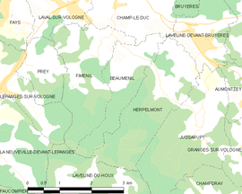
Neighboring communities of Beauménil are Champ- le- Duc in the north, Laveline -devant- Bruyeres in the northeast ( point of contact ), Herpelmont in the east, Laveline -du- Houx in the south and Fiménil in the West.
History
Beauménil belonged in the Ancien Régime to the Bailiwick of Bruyeres. The village had until now never a church. Was for the Catholics, and is the parish church of the Assumption ( Église de l' Assomption -de -Notre -Dame) in the near Champ- le- Duc responsible.
Demographics
Attractions
Hermit Cave
On the way from the south end of the village to 594 m high Col de la Vierge is below a rock overhang the Grotte de l' Ermite. The sandstone cave is three meters long, one meter wide and two meters high. Around the year 1775 lived a hermit who every Sunday - to be walked barefoot for six kilometers distant church in Champ- le- Duc - in both summer and winter. From the entrance of the cave on the northern slope of a mountain one has a wide view of the Volognetal and the mountain landscape around Bruyeres.
Economy and infrastructure
The largest company in the area is the paper mill Nova Tissue SAS in the near Laval -sur- Vologne, a subsidiary of the Italian Cartiere Luccese Spa ( Lucart ) just 1.5 kilometers northwest of the nuclear location Beauménil. The operation represents cartons forth for food packaging as well as paper towels, toilet paper and tissues. He continues the 150-year tradition of paper processing in Volognetal. There are also smaller agricultural and service enterprises in the village.
Transport links
The Volognetal following the road of Bruyeres after Docelles (D 44) leads north past Beauménil. The road is one of the two direct connections between Epinal and Saint- Dié, the two largest cities in the department. The nearest railway station is 3.5 km from the small town of Bruyeres on the run by the TER Lorraine railway line Arches Saint- Dié.


_rue_de_l%2527Ermite.jpg/1024px-Beaum%2525C3%2525A9nil_(88)_rue_de_l%2527Ermite.jpg)


_mairie.jpg/220px-Beaum%2525C3%2525A9nil_(88)_mairie.jpg)